Formosa Bank and its NW extension fronts the coast from Tanjong Tohor to Tanjong Seginting; off the latter point it merges into the 11m bank fronting the coast. The bank has a least depth of 3.3m and is steep-to on its NW and SW sides.
The bank which lies between the SE end of Formosa Bank and the coastal bank is marked by numerous fishing stakes and vessels are advised to navigate in this vicinity during daylight only.
Bukit Banang, 470m high, is the summit of a range of rolling hills which terminates at Tanjong Seginting. Four radio masts stand on its summit. Several bright white lights, visible for a considerable distance, are sometimes shown near the radio masts. A light is reported to ...
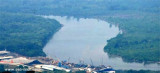
The Sungai Batu Pahat, SE of Muar, is fronted by a shallow flat which, extends up to 3 miles offshore. A depth of 0.3m exists on this flat near the river entrance at LW. Within the entrance there are depths of 2.5 to 5m as far as the town of Batu Pahat (Bandar Penggaram), about ...
Tanjong Tohor, a low point covered with jungle growth, is located about 13 miles SE of Muar. A 17.5m shoal lies near the main fairway about 11 miles Wof Tanjong Tohor.
Between Melaka and Tanjong Seginting, about 46 miles SE, the low, thickly wooded coast is bordered by a mud bank which extends up to 2.5 miles offshore in places. The Water Islands, centered about 8 miles SE of Melaka, consists of a group of six tree-covered islands of moderate ...
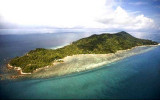
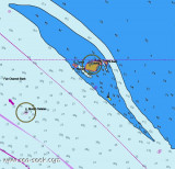
Pulau Pisang (English: Banana island) is a small island located off the Western coast of the Malaysian state of Johor. It is about 12 km from the town of Pontian Kecil and 5 km from Benut town. It is the siteof Pisang Lighthouse guiding ships into the western entrance of the Singapore ...


 Formosa Bank and its NW extension fronts the coast from Tanjong Tohor to Tanjong Seginting; off the latter point it merges into the 11m bank fronting the coast. The bank has a least depth of 3.3m and is steep-to on its NW and SW sides.