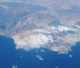
Punta Tortola, at about 3 NM SSW of punta San Pedro, has the appearance of an island, but it is joined to the shore by a low shingle spit. The summit of Punta Tortolas is steep and has several sharp peaks on it.
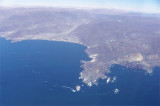
Punta San Pedro is the S point of Isla Blanca bay. It is steep and has a conspicuous high, round hummock a short distance inland. Reefs extend about 0.5 NM from the N side of the point. The W side of the point has rocks which extend about 0.3 NM offshore.
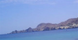
Punta Taltal, S point of the Nuestra Senora bay, is low.
Taltal point is NE of the point.Islote Afuera, with a rock close N of it, lies on a reef which extends about 0.2 NM N from the point.
Punta Ballenita is 46 m high.Tope Blanco islet, which has a white summit, lies about 1 NM W of the point.The passage between the island and the point is not recommended for navigation.
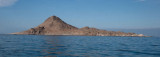
Isla Pan de Azucar ("Sugar Loaf") is about 0,5 NM offshore with its E extremity. The island appears light brown and whitish in color. There are two peaks on the island, with the highest near the center. Above-water rocks extend nearly 0.5 NM NW from the island. The outermost ...


 Close N of Punta Tortolas, is a narrow cove where vessels load copper ore.
  A l'extrémité N de Punta San Pedro se trouve cette anse étroite où les navires chargent le minerai de cuivre.
")