East London

East London

To precisely geolocate this site. Update if necessary.

Localisation

East London
LatitudeLongitude
DMS------
DM------
DD------

Characteristics

Port
Water
Fuel
First aid
Shipyard
Grocery

Description

Port .
2012/02/12
Update
Port .
2012/02/12
Update
East London
2012-02-12
Update
Share your comments or photos on "East London"

Sites around East London

Flying distances - Direct line

Port Elizabeth

126nm
243°
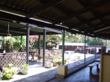
Harbour protected by a breakwater. Algoa Bay yacht club walk ons, resturant and pub great meeting place for old salts. very protected bay from the ocean great playground for all sizes of yachts and boats never overcrowded, fishing excellent good winds for sail.
13 Jun 14
sasail

Durban Bluff Yacht Club

245nm
40°
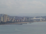
Tout au fond du port de commerce, le Bluff Yacht Club.A good stop over spot for running repairs or just to unwind clear the salt. Great bunch of members ever willing to help with what ever. public transport is non existing, can be a problem but then the live on board members ...
13 Jun 14
sasail129@gmail.com

Durban

247nm
40°
Large harbor protected by a breakwater.
23 Jun 14
sasail129@gmail.com

DURBAN Marina

247nm
40°
...Marina dans le port de commerce de Durbanhttp://durbanmarina.co.za/?page=0Il y a un autre "club de voile" tout au sud... "Bluff Yacht Club"http://www.bluffyachtclub.co.za/
27 Nov 13
phil de tudo bem

Mossel Bay

296nm
256°
Port protected by a breakwater.
12 Feb 12
Gensogaiden

Richards Bay

332nm
40°
Harbor protected by a breakwater.
12 Feb 12
asain