Mouillage spendide (le plus beau de l'archipel). Sauvage (du moins au mois d'octobre)Faire le tour du caillou qui bouche la baie en plongée (masque et tuba suffisent) 2005-10-28°
2007-07-11
Update
Mobile
2007-12-30
Update
2007-12-30
Update
Tout près de la fenêtre d'azur, la mer intérieure (Inland Sea) constitue une autre curiosité de la nature: la mer pénètre par un tunnel naturel dans une cuvette où l'eau est sans cesse renouvelée.
2007-12-30
Update
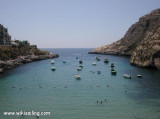
Almost circular bay at W of Gozo.We usually anchor on shore N carrying a mooring line. With the usual NW wind a little surf settles, it is normally more uncomfortable than dangerous.
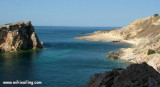
In strong wind NW-SW it is not good to be there. In the middle of the entrance is the rock "Fungus Rock" which owes its name to the type of mold that was once collected for its medicinal properties.
Dwejra is one of the most spectacular dive sites in Malta, with deep water (60 meters) and many caves and arches.
2019/06/1
Update
azerty
Baie presque circulaire à l'W de Gozo.On mouille habituellement sur la rive N en portant une amarre à terre. Avec le vent habituel de NW un peu de ressac s'installe, il est normalement plus inconfortable que dangereux. Par vent fort de NW-SW il ne fait pas bon s'y trouver. Au milieu de l'entrée se trouve le rocher "Fungus Rock" qui doit son nom au type de moisissure qui était autrefois recueilli pour ses propriétés médicinales. Dwejra est un des sites de plongée les plus spectaculaires à Malte, avec de l'eau profonde (60 mètres) et beaucoup de grottes et d'arcs.
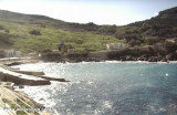
Minuscule indentation de moins de 100m de large, au SW de Gozo. Attention à une roche recouverte de moins d'1m d'eau au milieu de l'entrée. A l'intérieur, la crique est pleine de corps-morts pour les embarcations locales et même un petit yacht aurait de la chance d'y trouver ...
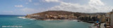
Marsalforn is a fishing village on the Gozo north coast. In the small harbour the depth is too reduced for most ships. Open at the N part, the winds of NW create deep swell.
Dahlet Qorrot is a small inlet nestled in the northern cliff face of Gozo and can be reached from Nadur. The cove is used by a small number of fisherman who have turned some caves into boat houses and storage areas for fishing gear and one can observe these fishermen mending their ...
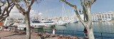
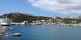
Mgarr est le seul port en eau profonde de Gozo. Le ferry qui fait la liaison entre Malte et Gozo relie Cirkewwa à Mgarr. Pour l'approche, les brises-lames se voient bien et les nombreux ferries allant et venant aident à bien localiserl'entrée. Danger: Attention aux ferries. ...
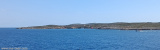
Situated on the E coast, in front of Comino. The bay is open from E and S winds. Yachts, boats and ships go there to enjoy its magnificence and tranquility.
The Blue Lagoon, between the small islands of Gozo and Comino, is Malta's greatest attraction. The crystal blue waters attract hundreds of boats every day. Cominotto est une plus petite île du coin nord-ouest de Comino. Au nord-ouest de Cominotto il y a un récif sous-marin. Ce ...


") Mouillage spendide (le plus beau de l'archipel). Sauvage (du moins au mois d'octobre)Faire le tour du caillou qui bouche la baie en plongée (masque et tuba suffisent)
Mouillage spendide (le plus beau de l'archipel). Sauvage (du moins au mois d'octobre)Faire le tour du caillou qui bouche la baie en plongée (masque et tuba suffisent)")
")
") Tout près de la fenêtre d'azur, la mer intérieure (Inland Sea) constitue une autre curiosité de la nature: la mer pénètre par un tunnel naturel dans une cuvette où l'eau est sans cesse renouvelée.
Tout près de la fenêtre d'azur, la mer intérieure (Inland Sea) constitue une autre curiosité de la nature: la mer pénètre par un tunnel naturel dans une cuvette où l'eau est sans cesse renouvelée.