Den Helder

Den Helder

To precisely geolocate this site. Update if necessary.

Localisation

Den Helder
LatitudeLongitude
DMS------
DM------
DD------

Characteristics

Water
Fuel
First aid
Shipyard
Grocery
Naval Base

Description

Port.
2011/08/8
Update
boratslo
Port.
2011/08/8
Update
boratslo
Den Helder
2011-08-08
Update
boratslo
Ebook

Nederland - Holland

  • 28 sites
  • 27 photos
  • publication date: 8 Jul 2023
  • .pdf file size: 31 Mb
Share your comments or photos on "Den Helder"

Sites around Den Helder

Flying distances - Direct line

Medemblik

16nm
133°
Regattacenter Medemblik
Vooroever 3
1671 SG Medemblik
The NetherlandsPOS: 52°46.19 N - 5°07.03 E
TEL:  +31 (0) 227 - 547781
FAX:  +31 (0) 227 - 547782
WEB: www.regattacenter.com
Email:  info@regattacenter.com
26 Jul 11

Hoorn

21nm
152°
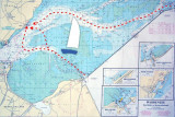
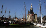
Founded in 1357, Hoorn become a major harbour town. During Holland's 'Golden Century', Hoorn was an important home base for the Dutch East India Company. In 1616, the explorer Willem Corneliszoon Schouten bravedstorms as he rounded the southernmost tip of America. He named it Kaap ...
31 Dec 07

Ijmuiden

31nm
195°
Port on a river.
8 Aug 11
stamptuk

Marken

32nm
159°
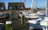
Marken is a peninsula alongside the picturesque Markermeer, the South part of the Ijsselmeer, Marken is well-known for its characteristic wooden houses.
Former island, which nowadays is connected to the North Holland mainland by a causeway.
A really nice place to visit
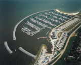
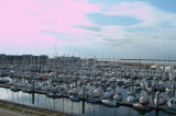
31 Dec 07