Chah Bahar

Chah Bahar

To precisely geolocate this site. Update if necessary.

Localisation

Chah Bahar
LatitudeLongitude
DMS------
DM------
DD------

Characteristics

Port
Water
Fuel
First aid
Shipyard
Grocery

Description

Small port.
2012/03/27
Update
KalyBrisse
Petit port côtier.
2012/03/27
Update
KalyBrisse
Ebook

Arabian Sea

  • 132 sites
  • 73 photos
  • publication date: 6 Jul 2023
  • .pdf file size: 49 Mb
Share your comments or photos on "Chah Bahar"

Sites around Chah Bahar

Flying distances - Direct line

Gwadar

94nm
97°
Harbor.
27 Mar 12

Jask

155nm
277°
Small port.
27 Mar 12
GEAKTE

Mina Qabus

150nm
227°
Small port protected by a breakwater.
27 Mar 12
futuremark

Khor Fakkan port Sharjah

229nm
270°
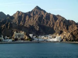
Khor Fakkan (or Khawr Fakkan) is a town located along the Gulf of Oman on the east coast of the United Arab Emirates (UAE). The town is set on the picturesque bay of Khor Fakkan, which means "Creek of Two Jaws".
Khor Fakkan belongs to the emirate of Sharjah but is geographically ...
14 Oct 11

Fujairah Port

230nm
268°
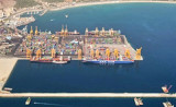
Port of Fujairah (or Fujayrah) is the only multi-purpose port on the Eastern seaboard of the United Arab Emirates, approximatly 70 natuticak miles from the Straits of Hormuz.
Initial Construction of the Port started in 1978 as part of the economic development of the UAE. Full ...
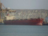
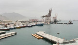
16 Oct 11
Joëlle

Port Of Sohar

222nm
257°
Port protected by a breakwater.
27 Mar 12
Macquart