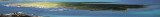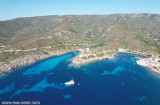


Area Marina Protetta di Capo Caccia - I. Piana (Sardegna)
22nm
181°
20 Nov 12
Joëlle
| Latitude | Longitude | |
| DMS | --- | --- |
| DM | --- | --- |
| DD | --- | --- |


")
")
")
Ebook | Sardegna North West
|

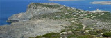
 Le cap Falcone, pointe extrême située au NW de la Sardaigne, est prolongé par une petite péninsule dont le sommet s'élève à 190 m et est surmonté par la tour Falcone qui est remarquable.
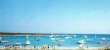
La tour aragonaise de la Pelosa, a donné le nom à la plage qui se trouve en face.
La petite île est joignable à pied depuis la plage en suivant un gué naturel. Il promontorio di Capo Falcone è la punta estrema a NW della Sardegna. Il promontorio prende il nome da una torre saracena chiamata appunto Torre del Falcone, edificata nel 1578, antico baluardo difensivo che sovrasta il colle eche è notevole.
La torre aragonese della Pelosa , dà il nome alla spiaggia in fronto.
L'isolotto è raggiungibile a piedi dalla spiaggia seguendo un guado naturale.Ebook | Sardegna
|