Cap d'Ail - Cap Martin
2.1nm
259°
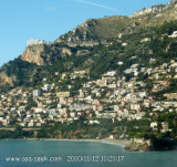
Le cap Martin est couvert de pins d'où émerge un sémaphore blanc sur les hauteurs.
1 Dec 07
| Latitude | Longitude | |
| DMS | --- | --- |
| DM | --- | --- |
| DD | --- | --- |

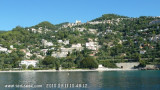
 Mouillage au NW du cap
 Mouillage au NW du cap
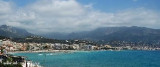
 Situated between Monaco and Menton, the town of Roquebrune-Cap-Martin is in the hillsides overlooking the Mediterranean Sea shore of 7km.
 Le cap est couvert de pins d'où émerge un sémaphore blanc, sur les hauteurs.
 Cote d'Azur
 Situata tra Monaco e Mentone, la città di Roquebrune-Cap-Martin è in riva del mare Mediterraneo, su sette chilometri, sicuro a il fiotto. Il capo è aperto a il fiotto d'E. Al capo c'è uno semaforo bianco.
Ebook | Côte d'Azur - French Riviera
|