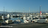
Harbour sheltered from all winds except for outer port which is exposed to E.
654 berth incl. 246 visit.
The shore of the bay between the two harbors is fronted by numerous
prominent buildings and hotels. The town of Cannes stands at the foot of
the hills, which rise from the N shore of the Golfe de la Napoule.
Anchorage may be taken, in depths of 12 to 35m, mud and weed, within a designated area, the limits of which are shown on the chart, lying 0.5 mile S of Cannes. The anchorage is used by cruise ships.
2011/07/17
Update
Atoi
1. Capitainerie
2. Douches - Toilettes
3. Poste de sécurité
4.Station d'avitaillement
5. Conteneur à huile
6.Transports côtiers
7. Gare routière
8. Office de tourisme
2011/07/17
Update
Atoi
Port abrité de tous vents sauf l'avant-port exposé au vent d'E.
T. +33 4 92 98 70 20
F. +33 4 92 98 70 01
654 pl. dont 246 visit.
2013/07/22
Update
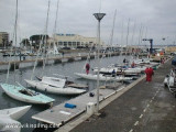
Rechargement bateaux électriques
2020-06-12
Update
Anonymous
Vieux Port de Cannes
2020-06-12
Update
Anonymous
Share your comments or photos on "Cannes - Vieux Port"
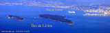
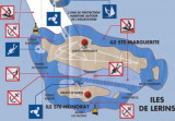
Ile Saint-Marquerite, the bigest island close to the city of Cannes, lies centered 1 mile SSE of Cap de la Croisette and is very wooded. A conspicuous citadel, in which there is a disused signal station, stands near the middle of the N coast of the island. A small shipyard is situated ...
Zone de mouillage largement fréquentée en été durant les feu d'artifices en face de la célèbre croisette. L'abris est médiocre mais acceptable les jours de beau temps.
A leading marina in Europe, Port Canto is located at the end of Croisette N of the Palm-Beach jetty. 600 berths incl. 100 visit. (<90 m)
Sailing vessels do not have the right of way over power-driven vessels within Rade de Cannes and Cannes harbor. The speed of vessels within ...
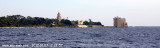
A conspicuous chateau stands on a projection on the S coast of the island. The belfry of an abbey, which emerges from the surrounding trees close N of the chateau, is prominent. The E extremity of the island is surrounded by small islets and rocks which extend up to 0.3 mile from ...
Cannes bay is located between Pointe de l'Aiguille and Cap de la Croisette, 4 miles ENE, from which the islands "Les Îles de Lerins" extends up to 2 miles. The E side of the gulf is occupied by the town and port of Cannes well known by it's film festival, where the houses form ...
A prominent casino stands on Cap de la Croisette. A hill, 245m high, stands 1.7 miles NNE of Cap de la Croisette and is surmounted by a prominent water tower; a large hotel stands halfway up this hill and is conspicuous. The conspicuous Observatoire du Grand Pin surmounts the summit ...


 canal 12


 dans le port
 Entrée de Vieux port. Vue lors du salon de la plaisance 2007.

 Harbour sheltered from all winds except for outer port which is exposed to E.
 Rechargement bateaux électriques