Calais is the most important port for cross-channel ferry traffic from England. It also provides extensive facilities for commercial shipping and is connected to the network of canals in the N part of France.During strong winds from WSW, through N, to ENE, a very heavy sea may be created in the harbor entrance and entry is sometimes impossible. A strong swell may be experienced within the harbor in such conditions.
2012/05/4
Update
2nids
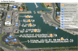
Le port de Calais dispose d’un bassin de plaisance à flot qui abrite à
longueur d’année 262 unités, voiliers ou bateaux de pêche auquel il faut
ajouter un bassin d’échouage de 45 places, soit un total de 307
anneaux.
Ce port est utilisé par les plaisanciers qui veulent traverser la manche au plus court vers l'Angleterre.
Informations
Données pour la plaisance sur http://www.calais-port.com/bassin_plaisance.html Bar Yachting Club tèl: 03 21 97 02 34 Horaires d'ouverture du pont permettant l'accès au bassin de plaisance sur http://www.calais-voile.fr
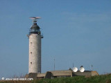
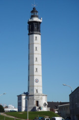
Le phare de Calais est un phare d’atterrissage. C’est une aide à la navigation pour les navires qui entrent au port, et un repère pour ceux qui croisent dans le Détroit du Pas-de-Calais, le plus fréquenté du monde.
A small port, lies 1 mile SE of the coast. It is used by fishing vessels, coasters, and pleasure craft. The harbor consists of Avant-port and Bassin Vauban, a wet basin. The entrance to Avant-port lies at the mouth of the Riviere Aa. The port is approached from Passe de l’Ouest. ...
Cap Gris-Nez (50°52'N., 1°35'E.), a precipitous headland, is 50m high and steep-to on its W side. A light is shown from a conspicuous tower, 31m high, standing on the cape. The CROSS surveillance station and a radar tower are situated close N of the light. Pointe du Riden, located ...
Port Ouest is protected by two angled jetties which form an entrance, 450m wide. It consists of Avant-port, 1 mile long, and Bassin de l’Atlantique, a large tidal basin. The entrance channel, leading SE into Avant-port from Passe de l’Ouest, is dredged to a depth of 20m. The ...


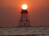
 coffre avant port
 Calais Port : 17


 Le port de Calais dispose d’un bassin de plaisance à flot qui abrite à
longueur d’année 262 unités, voiliers ou bateaux de pêche auquel il faut
ajouter un bassin d’échouage de 45 places, soit un total de 307
anneaux.
Le port de Calais dispose d’un bassin de plaisance à flot qui abrite à
longueur d’année 262 unités, voiliers ou bateaux de pêche auquel il faut
ajouter un bassin d’échouage de 45 places, soit un total de 307
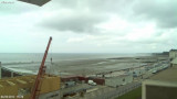
anneaux. Avant-Port et Port de Calais