Le Cap d'Ail marque la séparation entre les baies de Beaulieu et de Monaco. Les abords étant malsains, il faut s'en écarter assez largement. Le cap Martin est couvert de pins d'où émerge un sémaphore blanc sur les hauteurs.
The Presqu'ile de Saint Hospice , 40m high, forms a peninsula which extends E from the center of the E side of the Cap Ferrat promontory. It is surmounted by a chapel and a conspicuous tower Pointe Saint Hospice, located 1.2 miles NE of the Cap Ferrat Light, is the E extremity of ...
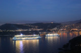
Rade de Villefranche is entered between Pointe des Sans Culottes, the SE extremity of the Mont Boron promontory, and Pointe Malalongue, the SW extremity of Cap Ferrat, 1 mile SE. The bay extends N for 1.5 miles and offers sheltered anchorage to vessels of any size. It is used by vessels ...
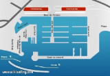
The port is situated In W bay, hardly visible from the sea. The entrance there is two passages: The S passage for boats with shallow drafts (<3m) The N passage by rough sea or by night. 750 berths inc. 156 visit. (<45 m). tel 04 93 01 10 49 Fax 04 93 01 14 12
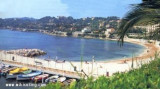
Zone importante de mouillage surtout avec du vent d'Est. On peut mouiller également- un peu plus au nord: anse Grassuet- au sud: anse de Passable : un peu de sable et beaucoup d'herbiers


 canal 9


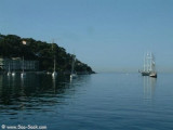
 Port-abri situé à l'W de la baie de Beaulieu.
 Porticciolo situato all'W della baia di Beaulieu.