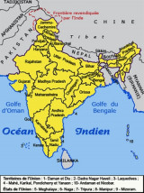
Arabian Sea The Arabian Sea is a northwestern extension of the Indian Ocean, positioned between India, Oman, Pakistan and Yemen, and Cape Guardafui in far northeastern Somalia. The sea connects with the Persian Gulf through the Gulf of Oman and the Strait of Hormuz. In the southwest, the Gulf of Aden connects it with the Red Sea. The most significant ports in the Arabian Sea include Karachi, Pakistan, and Mumbai, India.
Between Diu Head (from N) and Cape Rama (to S), there is the gulf of Cambay and the largest sea-port on the W coast of India, the port of Mumbai (Bombay), the largest seaport on the W coast of India. An extensive offshore area is being developed for oil production. Numerous ...
The Gulf of Oman is a western extension of the Arabian Sea, positioned in the Middle East between Iran, Oman and the United Arab Emirates. It's the entrance to the Persian Gulf from the Arabian Sea and Indian Ocean,


 Arabian Sea