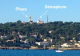
The highest point of the Cap d’Antibes peninsula. It dominates the E shore of gulf Juan. A light is shown from a square white tower with a red lantern, 24m high, standing on this point. A signal station and a prominent chapel are situated close NE and close SW, respectively, ...
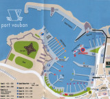
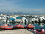
Antibes (Port Vauban) is an ancient town standing on a promontory which separates the harbor from the small bay to the S. The harbor has extensive facilities for pleasure craft, yachts, and fishing boats. Vessels can anchor E or NE of the harbor entrance, but the bottom of fine ...
Anchorage can be taken, in depths of 18 to 20m, sand and weed, good holding ground, within Anse de La Garoupe, which is entered between Cap Gros and Pointe Bacon, 1 mile N.
Situé au sud du port Gallice, à l'w du cap d'Antibes. Un épi en Y protège l'ancien petit abri de pêcheurs du Crouton dont l'accés est indépendant. Mouillage possible au sud du port. Protégé du Mistral. Le restaurant de la Maison du Pêcheur sur le terre-plein qui ...
Port on the West side of the cap d'Antibes . The port entrance is marked by two lights (red-green). Facing S-S-W, its entrance opens to N-N-W assuring totally calm waters within the port which is completely protected from all winds. 524 berths incl. 50visit. Lenght maxi. 45 m


 Mouillage en face de la plage de la Salis et au nord les remparts du vieille Antibes.