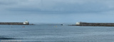
Iles de Glenan are a large group of islands, islets, and reefs which lie on an extensive bank. Several narrow channels lead between the islands and shoals of Iles de Glenan, but they are only used by small vessels with local knowledge.
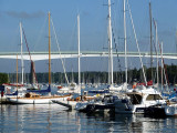
Le Port de Sainte Marine, port naturel en eau profonde situé sur la rive droite de l’Odet, accessible par tous les temps. Port de plaisance et de pêche, il offre l’enchantement de la mer dans les bois.
Plaisance : 770 places : 350 sur pontons dont 50 places visiteurs ...
This small port, lies within the mouth of the Riviere Odet, at the N end of Anse de Benodet.There are several marinas in the vicinity; the harbor has extensive facilities for yachts and pleasure craft. There is a small quay, which dries, and mooring buoys in the river . The approach ...
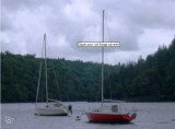
This small harbor is located at the W side of the bay. It lies on the S side of the mouth of theRiviere de Pont l’Abbe and is used by pleasure craft and fishing vessels. There are depths of 2 to 4m alongside the quays.Vessels with drafts up to 5m can enter at springs; vessels with ...