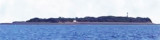
Piram Island, 11m high and composed of sand, lies with its N end about 2.8 miles SE of Kuda Point. At the S end of the island there are a few trees and a little cultivation; the NE side is fringed by a few mangrove trees. The lighthouse is conspicuous near the middle of the island; ...
The coast between Gopnath Point and Kuda Point, about 28 miles NNE, is low and covered with sandhills for about 18 miles to Mitivirdi; then it is comparatively high, with several ravines close to the coast. The country is flat and cultivated,with many scattered villages mostly ...
The coast between the entrance of the Sena River and Luhara Point, about 18 miles N, is low and marshy. It is intersected by several streams and rivers, and is flooded at spring tides from 1 to 4 miles inland.The Narmada River flows into the Gulf of Cambay, S of Luhara Point, through ...
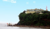
Gopnath Point, the W entrance point of the Gulf of Cambay, is moderately high, with a conspicuous light structure and bungalow on it. A temple, 23m high, lies near the coast, about 0.8 mile N of the point.A reef, which dries 2.7m, extends about 1.5 miles ENE from Gopnath Point.Gopnath ...
Dani Point Light is shown from a steel framework structure, 26m high, about 2.5 miles SE of the entrance to the Sena River. Gulwala Bank, with depths of less than 11m, extends about 6.3 miles S from a position about 3.5 miles W of the S entrance point of the Kim River. There is ...