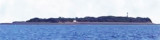

Piram island (W Cambay gulf - India)
11nm
250°
The lighthouse is conspicuous near the middle of the island; ...
1 Mar 12
Jojo
| Latitude | Longitude | |
| DMS | --- | --- |
| DM | --- | --- |
| DD | --- | --- |

 The coast between the entrance of the Sena River and Luhara Point, about 18 miles N, is low and marshy. It is intersected by several streams and rivers, and is flooded at spring tides from 1 to 4 miles inland.
The Narmada River flows into the Gulf of Cambay, S of Luhara Point, through a wide estuary in which there are extensive sand banks which dry and are subject to change. The river itself also contains many sand banks with channels between them, which are mostly shallow and very intricate.
The flood current entering the Narmada River flows until about 1 hour after the time of HW, and sometimes attains a velocity of 5 to 6 knots. The ebb sets out strongly and runs occasionally until 1 hour after the time of LW.
During the flood tide there are heavy overfalls on the outer edge of the bar.
Alia Bet, low and covered with small scrub, lies in the middle of the estuary.
Mariners should navigate with caution off the S part of the estuary of the Narmada River, as the depths have changed considerably.
Tides—Currents: The tidal currents on the E side of the Gulf of Cambay set in a NE direction with the flood tide and in a SW direction with the ebb, except when their direction is altered by the sand banks.
Luhara Point, the N entrance point of the Narmada River, is the highest
ground in the vicinity; the land is generally low, and consists of sand
hills covered with trees. The highest sand hill, about 24m high, rises
just within Luhara Point. Luhara Point Light, with a racon, is shown from a white tower with red diagonal stripes on the point.
The drying coastal bank extends about 2.5 miles SSW, and about 1.3 miles W of the point. Bar Sands, which dry, lie close S of the S edge of the coastal bank, and are marked W by a red conical buoy.
Bharuch Roads is the roadstead W of the entrance to the Narmada River. The anchorage is unprotected, but the bottom is good holding ground of sand and mud. At the anchorage the tidal currents set N with the flood and S with the ebb; the flood runs for about 1 hour after the time of HW.
The coast between Luhara Point and Ban Creek, about 4.5 miles N, consists of moderately-high sand hills. Then to the entrance to the Dhadar River, about 7.5 miles farther NNE, the coast is low and composed of sand and mud.
Ebook | Arabian Sea
|