Sumatra W coast (Indonesia)
Numerous small streams discharge their waters on the W coast, but most of them are barred and only navigable by small craft. ...
| Latitude | Longitude | |
| DMS | --- | --- |
| DM | --- | --- |
| DD | --- | --- |

 Sumatra (Indonesian: Sumatera) is an island in western Indonesia, westernmost of the Sunda Islands.
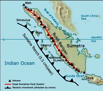
The longest axis of the island runs approximately 1,790 km (1,110 mi) northwest-southeast, crossing the equator near the centre. At its widest point the island spans 435 km. The interior of the island is dominated by two geographical regions: the Barisan Mountains in the west and swampy plains in the east.
To the southeast is Java, separated by the Sunda Strait. To the north is the Malay Peninsula, separated by the Strait of Malacca. To the east is Borneo, across the Karimata Strait. West of the island is the Indian Ocean.
The backbone of the island is the Barisan mountains chain, with the active volcano Mount Kerinci's 3,805 m the highest point, located at about the midpoint of the range. The volcanic activity of this region endowed the region with fertile land and beautiful sceneries, for instance around the Lake Toba. It also contains deposits of coal and gold.
To the east, big rivers carry silt from the mountain, forming the vast lowland interspersed by swamps. Even if mostly unsuitable for farming, the area is currently of great economic importance for Indonesia. It produces oil from both above and below the soil—palm oil and petroleum.
Sumatra is the largest producer of Indonesian coffee.

Ebook | Sumatra (Indonesia)
|


