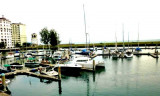

Lumut jetty (Perak - Malaysia)
1.2nm
92°
28 Dec 11
Jojo
| Latitude | Longitude | |
| DMS | --- | --- |
| DM | --- | --- |
| DD | --- | --- |


 (Malaysia)") Dinding river
Dinding riverEbook | Strait of Malacca (East)
|
 Lumut is a coastal town in the state of Perak in Malaysia and is the gateway to Pangkor island.
Lumut in Malay means moss, lichen, or seaweed.
In its early days, the beach is said to be rich in moss, so the local
people called it Lumut.
Lumut jetty now is the staging-off point to various beautiful offshore islands, including Pangkor Island.
Lumut is approached through River Passage and the Sungai Dinding.
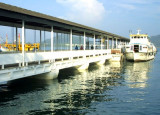
The principal functions of the port are the Lumut Naval Base, the Malayan Flour Mill, and the small pier at the town of Lumut used by coasters at high tide. Fishing boats and ferries dominate the area’s traffic.
There are three approaches to the river: one from the southwest and two from the north. All are well marked with buoys and beacons along the passageways.
Once inside the main river, the water is deep. Smaller local vessels often cross over shallow banks and should not be followed in a keel boat.
Tides_Currents:
The current through Selat Dinding sets S at a rate of 2 to 3 knots during spring tides. In the Sungai Dinding, both the incoming and outgoing currents have a rate of 2 knots during neap tides and 3.5 knots during spring tides.
Depths_Limitations:
The three channels leading to the main fairway of the Sungai Dinding and then to Lumut are, North Channel, North West Entrance, and Selat Dinding.
North Channel leads from Tanjong Hantu to Motts Point.
North West Entrance leads S of Beting Batu Malang and the N coast of Pulau Pangkor.
Selat Dinding leads from South Entrance close to the E coast of Pulau Pangkor. Selat Dinding is the channel most used by deep draft vessels calling at Lumut. A least depth of 11m is charted 0.5 mile NNE from South East Point Light.
All three channels meet at River Passage, 0.75 mile W of Motts Point.
Lumut Naval Base is surroundedby a hilly region and is protected from high winds and seas. The base is contained within two breakwaters, with lighted beacons on each end and a dredged basin with numbered berths inside.
Flour Mill Wharf has 167m of berthing space, with a depth alongside of 9.3m at MLWS. On the S side of the dock is a berth, 97m long, with a depth alongside of 6m, used by coastal tankers.
Lumut Maritime Terminal, situated on the Dinding River, is a common-user terminal. Dry bulk, bulk liquids, containers, and general cargo are handled here. The South Berths are 200m in length, with a depth of 10m alongside. The North Berths are 280m in length, with a depth of 12m alongside. A barge berth can accommodate two barges up to 8,000 dwt each.
Lekir Bulk Terminal is L-shaped and handles bulk liquids and dry bulk cargo for the adjacent power station. The S berth is 530m long, with 20m alongside, and can accommodate vessels up to 180,000 dwt. The N berth is 250m long, with 18m alongside, and can also accommodate vessels up to 180,000 dwt.
Pilotage.—Pilotage is compulsory and is available 24 hours.
The pilot boards S of Pulau Pangkor in position 4°10.5'N, 100°35.0'E. For vessels berthing at Lekir Bulk Terminal, the pilot boards in position 4°09'N, 100°33'E. A notice of arrival should be sent through the agent 72 hours in advance.
Regulations.—Entry is prohibited in the area centered on position 4°13.8'N, 100°35.3'E, as shown on the chart, where there is a degaussing range.
Entry is prohibited in the charted area E of Dinding Light, on the S side of the river to the N of the Lumut Naval Base to a position close W of Lumut.
Anchorage.—Anchorage may be obtained approximately 0.7 mile S of South East Point Light, in about 22m.
There are several submarine cable areas in the passage through Selat Dinding and the Sungai Dinding which can be best seen on the chart. Anchoring is prohibited.
Directions.—A vessel bound for Lumut using Selat Dinding should steer to pass 0.2 mile E of South East Point of Pulau Pangkor, with Tanjong Hantu open E of Batu Jambol. The fairway channel (Selat Dinding) is indicated by a lighted range, which may best be seen on the chart.
Continue N, maintaining the same distance off Tomb Point, Hospital Rock, and Batu Jambol. Then alter course to cross the bar of River Passage, keeping River Passage Buoy close to port on the inbound leg and close to starboard on the outbound leg.
Caution.—Vessels are advised not to use Northwest Entrance without local knowledge due to the numerous dangers.
 (Malaysia)")
 (Malaysia)") Razak submarine (Scorpene class)
Razak submarine (Scorpene class)Ebook | Sumatra (Indonesia)
|