Kelai, at the NE extremity of the atoll, was inhabited in 1970. Good radar returns have been reported from Kelai at 14 miles. The islet of Tinadu lies about 3 miles WSW of Kelai.
Maduni Faro, a lagoon reef, forms the NW extremity of the atoll. The islets of Marandu, Tukandu, and Miledu, the first two inhabited in 1970, lie, respectively, on the barrier reef between the N end of Maduni Faro and the islet of Gafuri, about 5 miles ESE. Gafuri ...
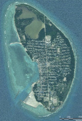
Kulhudhuffushi is one of the biggest and most populous island in the Northern part of the Maldives. People from the island is popular for shark fishing and working in cargo vessels. The island was affected by heavy rain and storms causing substantial damages in the ...
Warifuri Faro is a large lagoon with the islet of Warifuri at its S end. A lighted beacon lies on the N side of Warifuri Faro. The islets of Dedu and Warifuri are inhabited; the islet of Noradu lies between the latter two islets.
Muradu lies on a circular reef near the W edge of the atoll; the latest maps prepared from aerial photography (1968) show that this island has joined the islet charted 0.8 mile W of it.Some rocky patches lie S and SE of Muradu.
L'île de Numara, avec l'îlot de Nu proches NNO, se trouve au coin nord-est de l'atoll de Miladummadulu. Une ouverture très large dans la lagune se trouve entre Numara et Fivaku, environ 9 miles ESE.


 Kulhudhuffushi Regional Port (KRP) was officially inaugurated on 05th December 2005.
")
")