The coast between Ko Phuket and Pulau Pinang, 180 miles SSE, is generally low with some hills near the mountainous island of Pulau Langkawi. Islands and islets project widely from the coast, fringed by a coastal bank covered by little water.
The mouths of rivers are generally encumbered by bars.
Ko Phuket (48 km from N to S and 21 km from E to W), which is part of Thailand, in the Andaman sea, is separated from the W coast of
the Malay Peninsula by the narrow channel Chong Pak Phra. Chong Pak Phra
has a length of 12 miles and a width of about 0.4 mile at its W
entrance. ...
The Butang group, part of Tarutao Marine National Park,
provides the clearest waters and most beautiful coral
gardens in the area. In their efforts to keep the coral in prime
condition, the Thai authorities are levying heavy fines for any
vessels found to be anchoring on the reefs. ...
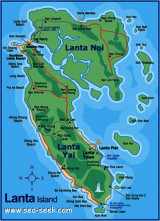
Ko Lanta Yai and Ko Lanta Noi are islands of Lanta archipelago, in S Thaïland, in the Andaman sea. They are separated from the S side of Ko Klang by a narrow shallow channel.From seaward these islands appear as one.The N part of Ko Lanta Yai is mostly flat and low-lying with several ...
Koh Tanga and Koh Chuku, halfway between Butang and
Tarutao offer great snorkelling, diving and fishing. The best anchorage is found on the east or west coasts
between the north and south Tangas, depending on wind
direction and ground swell. Alternative daytime anchorage
can ...
Big desert island, with a significant advantage over its cousins, that of having fresh water, Ko Rawi is located N of Ko Butang, E of Ko Adang. Its SE coast is populated with coral reefs and tropical fish.


 The coast between Ko Phuket and Pulau Pinang, 180 miles SSE, is generally low with some hills near the mountainous island of Pulau Langkawi. Islands and islets project widely from the coast, fringed by a coastal bank covered by little water.