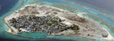
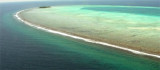

Aligau pass (Fadiffolu)
21nm
38°
27 Feb 13
dd
| Latitude | Longitude | |
| DMS | --- | --- |
| DM | --- | --- |
| DD | --- | --- |

 Kardiva Channel, deep and free from dangers in the fairway, lies between Fadiffolu Atoll, South Malosmadulu Atoll, and Horsburgh Atoll to NW, and Male Atoll and Ari Atoll to SE.
This channel divides the Northern from the Central atolls of the Maldives.
This channel was important for ancient mariners plying along the spice route trying to bypass the long and dangerous shallow reefs of the Maldives without harm.
In the British Admiralty charts it is called Kardiva Channel. It appeared on the old French maps as Courant de Caridou. Locally it is also referred to as the northern part being the Kaashidhoo Bodu Kandu and Kaashidhoo Kuda Kandu the southern part.
Tides—Currents.—The tidal current sets ENE through Kardiva Channel with the flood and WSW with the ebb, at a velocity of 2 knots.
During the Northeast Monsoon, the tidal current is inappreciable during the flood, but the ebb is reinforced by the surface current generated by the monsoon. Similarly, during the South west Monsoon the ebb current is weak or absent and the flood current is strong.
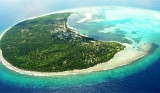
Aspect.—The N side of the E entrance of Kardiva is welldefined by Olivelifur, at the SE end of
Fadiffolu Atoll.
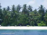
Kardiva, about 19 miles farther SSW, is a good landmark from the E, having two conspicuous palm trees on the N side of the reef upon which it lies.
Gaha Faro Reef, on the S side of the entrance to Kardiva, has no landmarks on its N and S sides.
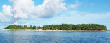
The W entrance of Kardiva Channel is not easily identified as the wooded islets on Ari and Horsburgh Atolls lie several miles within the salient points of their barrier reef. However, Toddu, an island off the N end of Ari Atoll, can be sighted at a considerable distance, and forms a good landmark in the approach from W.
Caution.—Kardiva was reported to lie about 2.3 miles SSE of its charted position.
Ebook | Maldives
|