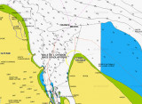
Îles du Salut (French Guiana)

Îles du Salut (French Guiana)

Per individuare con precisione. Aggiornare se necessario.

Localizzazione

Îles du Salut (French Guiana)
LatitudeLongitude
DMS------
DM------
DD------

Caratteristica

Isola / Atoll

Descrizione

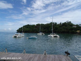
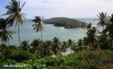
Îles du Salut, 3 in number, are  located about 7 NM NE of Pointe Charlote.Ile du Diable, the northernmost, is 40m high. Ile Royale, 66m high, is the largest and westernmost, while Ile Saint-Joseph, only 30m high, is the southernmost.

On a clear day, the islands are visible at a distance of 15 miles.

The anchorage at Iles du Salut is the most important anchorage along the coast of the Guianas, this being due to the few ports along this coast capable of affording shelter
to ships of moderate size.
2016/01/20
Aggiornare
Joëlle
Îles du Salut (French Guiana)
2016-01-20
Aggiornare
Anonymous
Condividi i tuoi commenti o le foto su "Îles du Salut (French Guiana)"

Siti intorno a Îles du Salut (French Guiana)

Flying distances - Direct line

Devil's Island

0.3nm
45°
Île du Diable part of Salut islands is better known as Devil's Island. The total area is 0.62 km2 (62 hectares) The islands were used as a penal colony from 1852 onwards, earning them a reputation for harshness and brutality. This system was gradually phased out and has been completely ...
20 Jan 16
Joëlle

Ile Royal (French Guiana)

0.2nm
202°
On peut venir aussi en monocoque, tirant d'eau 1.80 m, sans soucis...
20 Jan 16
phil de tudo bem

Île Saint-Joseph (French Guiana)

0.3nm
155°
Anchorage can be taken in the bight formed by the S side of Ile Royale and the W side of Ile Saint-Joseph.
20 Jan 16
Joëlle

Port of Saint laurent du Maroni (French Guiana)

87nm
278°
Un site sympa très calme surtout à l'abri des intempéries. Vous tomberez sous le charme de cette ville dont l'histoire est particulièrement intéressante avec les vestiges du bagne, les nombreuses populations d'origines diverses.Plus d'infos : eileen_of_avoca@yahoo.com
21 Jan 16
Joëlle

Cabo Orange (N Brazil)

81nm
129°
Cabo Orange (cape Orange) is a cape on the N coast of Brazil, separated from the coast of French Guiana by a large bay watered by the estuary of the Oyapock River Cape Orange is the northernmost point of the Brazilian state of Amapá. It is located in an area of tidal marshland protected ...
10 Jan 16
Joëlle