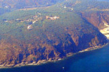

Pigeon Island Gangavaram (Andhra Pradesh-NE India)
0.7nm
37°
5 Apr 12
Jojo
| Latitude | Longitude | |
| DMS | --- | --- |
| DM | --- | --- |
| DD | --- | --- |


 Gangavaram Port is located at Visakhapatnam, the industrial nerve center of Andhra Pradesh.
The coast here forms a bay between Yarada Hill at north and Mukkoma
Hill at south. A creek in between these two hills forms Balacheruvu
Lagoon, where the natural port of Gangavaram has been developed.
Gangavaram Port is located at Visakhapatnam, the industrial nerve center of Andhra Pradesh.
The coast here forms a bay between Yarada Hill at north and Mukkoma
Hill at south. A creek in between these two hills forms Balacheruvu
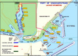
Lagoon, where the natural port of Gangavaram has been developed.Gangavaram Port is India's deepest port. It has a depth of 21m. Gangavaram Port provides efficient cargo handling services for a variety of bulk and break bulk cargo groups including Coal, Iron Ore, Fertilizer, Limestone, Bauxite, Raw Sugar, Project Cargo, Alumina, Steel products etc.
The Port, its related facilities and material handling system are among
the most advanced in Asia and meet the highest standards in terms of
pollution prevention and safety.
Berthing Facilities (5 Berths: Iron Ore 1; Coal 1; Multipurpose 3)
Depth in harbor 19.5m below CD
Mechanized Coal and Iron Ore discharge and loading systems for vessels upto 200,000 DWT
Mechanized Wagon Loading and Wagon Tippling System
New generation Mobile Harbor Cranes for other bulk and break bulk cargoes
Iron ore stackyard and coal stackyard with storage capacity of more than 1 MMT and 2 MMT respectively
Covered transit storage for bulk and break cargoes
Tel: +91 404 4349999
Fax:+91 404 4349990
Mail: port@gangavaram.com
")
")
Ebook | Bay of Bengal
|