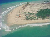

Sawai bay (Car Nicobar)
3nm
344°
Foul ground extends 1 mile N from Keating Point and 0.5 mile N from Hog Point. Sawai Village lies 0.5 mile SE of Hog Point.
The tidal currents off Sawai Bay set NE on the flood tide.An ...
28 Nov 11
Jojo
| Latitude | Longitude | |
| DMS | --- | --- |
| DM | --- | --- |
| DD | --- | --- |

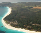
 Car Nicobar island, or PU in the local langage, the N island of the group, lies about 77 miles SSE of Little Andaman Island.
 The island has been reported to be a good radar target up to14 miles.
The Car Nicobar is a very small Island, if compared with the Middle
Andaman or South Andaman. The area of Car Nicobar Island is around 127
Sq km. There are clusters of 15 villages, which are inhabited areas, the
largest being Malacca.
The 15 villages of Car Nicobar Island include Mus, Kinmai, Small Lapathy, Big Lapathy, Tapoiming,Chukchucha, Kinyuka, Tamalu, Perka, Malacca, Kakana, Kimius, Arong, Sawai and Titop.
The Car Nicobar Island was ravaged by the 2004 tsunami. Car Nicobar lies 750 km (465 miles) from the epicenter of the 2004
Indian Ocean earthquake, and the resultant tsunamis struck it with
immense force and witnesses reported that the waves were as high as 30
ft (9 m).
As of December 30, 2004, the number of casualties is actually unknown,
but seemed likely to be high. One survivor told the Associated Press
that there was not a single hut, which was standing. Most of the people
went up to the hills and were afraid to come down.
")
Ebook | Andaman sea
|