
Pulau Tuba (Langkawi)
4.7nm
175°
At Pulau Tuba, you can experience ...
27 Nov 11
Jojo
| Latitude | Longitude | |
| DMS | --- | --- |
| DM | --- | --- |
| DD | --- | --- |


 Bass Harbour est l'ancrage principal de ville Kuah, elle est formée entre la côte S de Pulau Langkawi et de la côte nord de Pulau Dayang Bunting, est à 7 miles de long avec une largeur moyenne de 1,5 miles et une profondeur générale de 5,5 à 7,5 m , fond vaseux ..
")
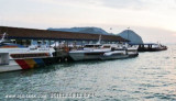
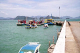
 Bass Harbour is the main anchorage for
Kuah Town, it is formed between the S coast of Pulau Langkawi and the N coast of Pulau Dayang Bunting, is 7 miles in length with an average breadth of 1.5 miles and a general depth of 5.5 to 7.5m, mud bottom..
Bass Harbour is the main anchorage for
Kuah Town, it is formed between the S coast of Pulau Langkawi and the N coast of Pulau Dayang Bunting, is 7 miles in length with an average breadth of 1.5 miles and a general depth of 5.5 to 7.5m, mud bottom..
At two hours either side of high tide, it is very handy for
provisioning by dinghy, either directly to Teow
Soon Huat supermarket in the NW corner of the bay, or to any
suitable location on shore.
If attempting to land dinghy at low tide, it's best to go Jetty Pelancongan, situated halfway between RLYC and Kuah Town.
This anchorage is only suitable for doing your shopping then moving out if
you want to swim or be assured of a good night's sleep.
BEWARE: The holding ground here is poor and your anchor will drag in SW squalls of over 20 knots that occur frequently during May-Nov.
DANGER: A dangerous unmarked rock lies just beneath the surface at Lat: 06.15.10'N Long: 99.44.90'E (SE of P. Selang at end of Bass habour).
Best months for anchoring: Dec - April. Not so good: May - Nov.
")
")
")
Ebook | Andaman sea
|