Baia do Santos (Sao Vicente)

Baia do Santos (Sao Vicente)

Per individuare con precisione. Aggiornare se necessario.

Localizzazione

Baia do Santos (Sao Vicente)
LatitudeLongitude
DMS------
DM------
DD------

Caratteristica

Costa

Descrizione

The entry of Bahia do Santos is located between Pta Monduba (on Ilha de Santo Amaro) and Pta Itapu (on Praia Grande)  At bottom of the bay is Ilha de Sao Vicente.

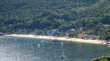
It is a wide bay and the shores of it consists of sandy beaches separated by small rocky points.

The E part of Ilha de Sao Vicente is separated from Ilha de Santo Amaro by a narrow buoyed channel which leads to Porto de Santos. There are general depths of 13 to 14.6m in the entrance to the bay and 7 to 10m in its N part.

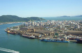
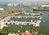
Santos consists of the navigable estuary between Ilha de Santo Amaro and Ilha do Sao Vicente and forms a semi-circle around the city.
The port serves the nearby city of Sao Paulo and is the largest port in South America.
The approach channel, marked by buoys and ranges, is about 5 miles in length and is entered 2.25 miles SW of Ponta Grossa. The harbor channel is entered between Ponta da Praia to the N and Ponta de Fortaleza to the S.

Between Ponta de Itaipu, the W entrance of Baia de Santos, and the mouth of Rio Itanhaem, about 23 miles to the WSW, the coast is generally low.
2016/01/19
Aggiornare
Joëlle
Baia do Santos (Sao Vicente)
2016-01-19
Aggiornare
Anonymous
Ebook

SE Brazil

  • 46 sites
  • 55 photos
  • publication date: 8 Aug 2024
  • .pdf file size: 29 Mb
Ebook

SW Atlantic Ocean

  • 122 sites
  • 136 photos
  • publication date: 5 Aug 2024
  • .pdf file size: 60 Mb
Condividi i tuoi commenti o le foto su "Baia do Santos (Sao Vicente)"

Siti intorno a Baia do Santos (Sao Vicente)

Flying distances - Direct line

Yacht Club of Santos (Sao Paulo)

3.1nm
82°
Call prior to arrival. Visitors' dock. All facilities including haul out and a boatyard with all services. Small supermarket on site. Fuel berth. Note that the restaurant, bar, swimming pool and tennis courts are for members only and visitors are not permitted to use these facilities.

Tel:+55(0)13-3358-2980 ...
15 Jan 16
Joëlle

Port of Santos (Sao Paulo)

3.3nm
30°
Santos lies some 230 NM SW of Rio de Janeiro and is Brazil's biggest and most important port. The city lies partly on the island of St Vncent, and partly on the mainland. This is not an attractive stop but useful for repairs.
The port of Santos is located in the city of Santos, ...
19 Jan 16
Joëlle

Yacht club Ilhabela (Sao Paulo)

55nm
76°
Ilhabela est une petite ville au sud est du Brésil. Elle est située sur une ile, à environ 2mile du continent.. Le climat est tropical (en général chaud avec une température moyenne de 28/30° celsius).
20 Dec 07

Ensenada de Aracatiba (Ilha Grande)

121nm
65°
Enseada de Aracatiba is entered between Ponta Grande, 2.5 miles ENE of Ponta Acaia, and Ilha Longa, 1 mile NE and close offshore.
Anchorage is available in the bay, with good shelter, about 0.4 mile S of the W end of Ilha Longa, in a depth of 21m, mud.
18 Jan 16
Joëlle

Ensenada de Sitio Forte (Ilha Grande)

124nm
65°
Enseada de Sitio Forte is entered between Ponta Grossa de Sitio Forte, about 2 miles NE of Ilha Longa, and Ponta Aripeba, about 1 mile farther E. The head of the bay is formed by a small cove, the W side of which is foul.

Anchorage, sheltered from all winds, and the best on ...
18 Jan 16
Joëlle

Bahia Ilha Grande N shore ( Angra dos Reis)

140nm
63°
Baia de Mangaratiba is entered between Ponta do Bispo and Ponta da Cruz. This shallow bay is exposed to the sea, which breaks heavily on its NW shore. The town of Mangaratiba stands on the E side of the bay and has a small concrete pier.
Laje de Mangaratiba, low, dark-colored, ...
18 Jan 16
Joëlle