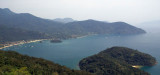
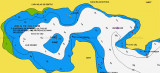
Lying about 60 miles west of Rio de Janeiro, this large bay with the
island of Ilha Grande in the middle, is one of the best cruising grounds
in Brazil. It is full of remote anchorages and quiet, traditional
fishing villages.
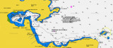
The E part of the bay, lying W of Baia de Sepetiba, is formed by the NE side of Ilha Grande and the coast to the N and is entered between Ilha da Marambaia and Ponta de Castelhanos.
The bays and coves on the NE coast of Ilha Grande afford excellent anchorage, but those on the mainland coast are generally exposed to winds from SE through SW, and to the swells caused by these winds.
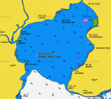
Baia de Mangaratiba is entered between Ponta do Bispo and Ponta da Cruz. This shallow bay is exposed to the sea, which breaks heavily on its NW shore. The town of Mangaratiba stands on the E side of the bay and has a small concrete pier. Laje de Mangaratiba, low, dark-colored, ...
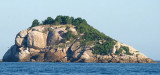
Ilha Pau a Pino is located about 3 miles N of Enseada das Palmas and rises sheer from the sea. The island has little vegetation, but shows a light. A rocky ledge extends about 0.2 mile SW from the island.
Enseada das Palmas lies 2,5 NM NW of Ponta de Castelhanos.
The bay is separated into two small coves by Pontinha.
Anchorage can be obtained in the SE part of the bay in depths of about 11m, and small craft may anchor off the head of the S cove, in a depth of about 7m.
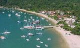
Enseada do Abraao lies about 2 NM NW of ensenada das Palmas. On the W shore of the bay are the large buildings of a disused quarantine station and a small landing pier.
Abraao, a small fishing village, stands at the head of the bay. Vessels drawing up to 3m can berth at ...


 Lying about 60 miles west of Rio de Janeiro, this large bay with the
island of Ilha Grande in the middle, is one of the best cruising grounds
in Brazil. It is full of remote anchorages and quiet, traditional
fishing villages.
Lying about 60 miles west of Rio de Janeiro, this large bay with the
island of Ilha Grande in the middle, is one of the best cruising grounds
in Brazil. It is full of remote anchorages and quiet, traditional
fishing villages.