ACI Marina Umag (Umago)

ACI Marina Umag (Umago)

Per individuare con precisione. Aggiornare se necessario.

Localizzazione

ACI Marina Umag (Umago)
LatitudeLongitude
DMS------
DM------
DD------

Caratteristica

Porto
Fango
Ancoraggio
VHF canal 17
Acqua
Elettricità
Gasolio
Meccanica di riparazione
Cantiere navale
Scivolo
Doccia
Wifi
WC
Lavanderia
Drogheria
Ristorante
Previsioni meteo

Descrizione

ACI Marina Umag (Umago)
2009:08:10 20:15:54
2010-03-08
Aggiornare
marceluisalonso
ACI Marina Umag (Umago)
2011-03-21
Aggiornare
Anonymous
ACI Marina Umag (Umago)
2011-03-21
Aggiornare
Anonymous
Ebook

Istrie (Istra)

  • 87 sites
  • 111 photos
  • publication date: 7 Jul 2023
  • .pdf file size: 46 Mb
La marina d'Umago se trouve sur la côte NW de l'Istrie, plus précisément elle est comprise entre la presqu'île où se trouve la ville d'Umag et la pointe Pegolotta (Rt Pakleni) au N. 
Elle est limitée au SW par un brise-lames courbe construit sur un banc couvert de moins de 3 m d'eau. Le musoir du brise-lames est marqué par un feu.

Le port de plaisance, protégé par un brise-lames occupe la partie NW de la baie.

Accès: En approchant du port on remarque la cheminée de l'usine de ciment au S de la ville.
Dangers: Attention au récif "Paklena", 1/2 M au NE de l'entrée du port et au rocher "Garofulin" au N de l'entrée.
  • Profondeur dans le chenal: 4 m; quai: de 2 à 6,5 m
  • 500 pl.
  • T. 00385.52741066
  • F. 00385.52741166
  • M. m.umag@aci-club.hr - www.aci-club.hr

On peut mouiller au N du quai de la ville, par 3 à 4 m. Mais attention ce n'est pas abrité des vents du N.
Le mouillage est payant.

2012/07/22
Aggiornare
Jojo
Umago marina is located on coast NW of Istrie, between peninsula where is Umag town and Pegolotta point (Rt Pakleni) at N.
It is limited at SW by a curve breakwater constructed on a bench covered with less than 3 m of water. The knuckle of the breakwater is marked by a fire.
The marina protected by a breakwater, occupies the NW of the bay.Access: When approaching the harbor the chimney of the cement factory located south of the town serves as a good landmark. The entrance into ACI marina Umag lies half a mile north.

Danger: Special attention should be paid to Paklena Shoal, half a mile on the northeastern side of the entrance to the harbor. Paklena Shoal is marked by a lighthouse (Fl (2) WR 8s 10m 8/6 M), which can be used as a way point (45°26,5' N 13°30,3' E).
The harbor is open to the northwest and one must enter it between a red lighted (Fl R 3s 2M) and green unlighted buoy. To the north, next to the red buoy there is a mark on a rock (black - yellow), which must be rounded from the south. When approaching, it is recommended to keep to a course of 60°. The light positioned on the breakwater (Fl (3) R 3s 8m 4M) is visible after passing the described buoys.

The sea depth in the marked channel is 4 m; wharf: 2 to 6,5 m

08 Mar 2010 19:39
Comment: marceluisalonso
marceluisalonso
it's olso posible be on the ankor, but it's necesary to pay if you use the buoys

2011/07/29
Aggiornare
Jojo
Condividi i tuoi commenti o le foto su "ACI Marina Umag (Umago)"

Siti intorno a ACI Marina Umag (Umago)

Flying distances - Direct line

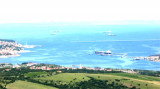
Koperski Zaliv (Baia di Capodistria) Slovenia

10nm
43°
Koperski Zaliv (Baia di Capodistria) est comprise entre Rt Ronco (Rt Ronek) au S et Rt Debeli, à 5 miles au NE.
Les rives nord et sud-ouest de la baie sont vallonnées, mais le rivage au fond de la baie, à travers lequel passe le fleuve Risano, est peu profond.
Monte Sermino, ...
28 Aug 11
Jojo

Piranski Zaliv (Baie de Piran)

4.1nm
30°
La baie de Piran, aussi appelée golfe de Piran, est une petite baie de la partie sud du golfe de Trieste, lui-même situé à l'extrémité septentrionale de la mer Adriatique, en Méditerranée. Elle est comprise entre Rt Madona au N et Rt Savudrija.
Si elle doit son nom à la ...
28 Aug 11
Jojo

De Porec au canal de Limski

15nm
169°
Attention: A partir de Porec jusqu'à l'entrée du canal Limski se trouvent de nombreux et dangereux hauts-fonds et rochers.
Sur le côté N de la baie de Funtana se trouve le haut-fond Janjci, dont la bordure N est marquée par une balise de danger isolé.
A l'entrée sud, ...
23 Jul 12
Jojo

Limski Kanal

19nm
159°
Le Limski Kanal se trouve entre Rt Kriz, à 2,4 NM au NW de Rovinj, et Rt Sjole, situé à 1 NM au NNW de Rovinj.La baie et la vallée de Limski est une particularité géographique trouvée près de Rovinj et Vrsar sur la côte occidentale de l'Istrie, au sud de Porec, en Croatie.La ...
31 Aug 11
Jojo

Baia di Muggia

15nm
43°
Baia di Muggia si trova tra Trieste e Muggia, cittadina nella SE estremo di Trieste. Confina con la Slovenia.
20 Mar 11
Joëlle

Luka Mirna (Baie Mirna)

8.1nm
158°
Cette grande baie est située au SW de Novigrad, entre le cap Meja et la pointe Zub qui porte un phare.
Attention, en venant du N, au hauts-fond "Plicina Val" signalé par une bouée non éclairée, face à Novigrad.
23 Jul 12
Jojo