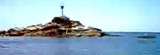
White Rock was reported to be a good radar target up to 13 miles. A light is shown from White Rock. A dangerous wreck lies about 9 miles, bearing 260° from White Rock; a racon is situated at the light.
Pulau Agas, the N of Kepulauan Sembilan, lies about 7 miles S of Southeast Point. The N group consists of four islets and a rock; the S group consists of six islands and two off-lying rocks, all within a 6 mile radius. Caution.—If approaching from S at night between the mainland ...
Pulau Tukun Perak (Fairway Rock) 5.5m high lies about 4 miles SSW of Southeast Point on Pulau Pangkor. A wreck, with a depth of 9.5m, lies 1.75 miles ENE of Pulau Tukum Perak.
Pulau Jarak, lying near the middle of strait of Malacca about 25 miles W of Kepulauan Sembilan, is a precipitous thickly-wooded island. Pulau Jarak was reported to be a good radar target.The flood current sets SE and the ebb NW, at a rate of about 1,5 knots, in the vicinity of the ...
Tanjong Beras Basah, the S point of the approach to the Sungai Perak, is fronted by sand banks, partly dry at LW, to a distance of 3.5 miles in a NW direction.
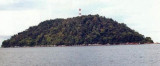
Mentangor is a large uninhabited island along S of Teluk Nipah.There were nothing worth
highlighting on the island except the scenes of rocky coast and some
tiny beaches. Next to it is the smaller, tiny Coral island with shallow water.
The Sungai Perak is approached through Kuala Perak, a wide shallow estuary and a buoyed channel leading E from the fairway lighted buoy. The Sungai Perak is navigable to Tuluk Intan, 30 miles inland for those vessels able to clear the shallow depth in the approach.Tides—Currents.—At ...


 (Malaysia)")