Walvis Bay

Walvis Bay

Pour géolocaliser ce lieu. Mettre à jour si besoin.

Localisation

Walvis Bay
LatitudeLongitude
DMS------
DM------
DD------

Caractéristiques

Port
Eau
Gasoil
Secours
Chantier naval
Epicerie

Description

Port côtier.
2012/02/12
Mettre à jour
evdokiya
Port.
2012/02/12
Mettre à jour
evdokiya
Walvis Bay
2012-02-12
Mettre à jour
evdokiya
Partagez vos remarques ou photos sur "Walvis Bay"

Sites autour de Walvis Bay

Flying distances - Direct line

Pelican Point Lighthouse

4.7nm
308°
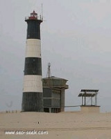
Pelican Point is the northern end of a long, low-lying peninsula of barren dune sand that forms the western side of Walvis Bay, protecting the bay from the Atlantic Ocean. In 1915 a small lantern was mounted on a wooden pole to mark the extremity of the peninsula. The present cast-iron ...
15 Jan 09
anonymous

Swakopmund Lighthouse

16nm
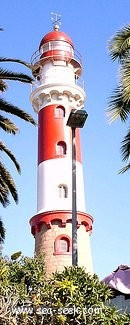
Swakopmund was founded in 1892, by Captain Curt von François.On 4 August 1892 the crew of a gunboat named Hyäne (German for Hyena) erected two beacons on a large dune, probably in the vicinity of the present lighthouse. This is regarded as the founding date of Swakopmund. 
15 Jan 09
anonymous

Cape Cross

76nm
336°
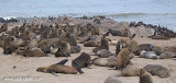
En 1486, l'explorateur portugais Diego Cao, premier européen à fouler le sol de la Namibie, dresse une croix en hommage au roi Jean 1er du Portugal. D'où le nom de Cap Cross.
Aujourd'hui,  Cap Cross est réputée pour sa colonie d'otaries à fourrure. Leur nombre fluctue ...
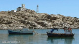
17 Jan 09
anonymous

Kalahari

188nm
172°
The Namibian coast of the Kalahari desert stretches for more than 400 kilometers. There are many beaches filled with sand dunes.
22 Aug 15
Madri_2015

Shark Island (Namibia)

224nm
170°
Shark Island, or German Haifischinsel, is a small island off the coastal city of Lüderitz in Namibia which is used as a campsite for tourists.
16 Jan 09
anonymous