Kalahari desert

Kalahari desert

Pour géolocaliser ce lieu. Mettre à jour si besoin.

Localisation

Kalahari desert
LatitudeLongitude
DMS------
DM------
DD------

Caractéristiques

Côte

Description

Partagez vos remarques ou photos sur "Kalahari desert"

Sites autour de Kalahari desert

Flying distances - Direct line

Kalahari

2.4nm
178°
The Namibian coast of the Kalahari desert stretches for more than 400 kilometers. There are many beaches filled with sand dunes.
22 Aug 15
Madri_2015

Shark Island (Namibia)

38nm
165°
Shark Island, or German Haifischinsel, is a small island off the coastal city of Lüderitz in Namibia which is used as a campsite for tourists.
16 Jan 09
anonymous

Luderitz

39nm
165°
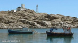
Lüderitz is located on the only part of the Namibian coast with a rocky shore not far from the old town of Kolmanskop. A peninsula with numerous coves, locally called fjords and bays, juts out of the coast at an angle to form the bay proper. Three small islands -- Penguin, Seal and ...
22 Jul 14
Diana

Walvis Bay

185nm
352°
Port côtier.
12 Feb 12
evdokiya

Pelican Point Lighthouse

189nm
351°
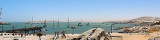
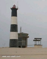
Pelican Point is the northern end of a long, low-lying peninsula of barren dune sand that forms the western side of Walvis Bay, protecting the bay from the Atlantic Ocean. In 1915 a small lantern was mounted on a wooden pole to mark the extremity of the peninsula. The present cast-iron ...
15 Jan 09
anonymous

Swakopmund Lighthouse

201nm
353°
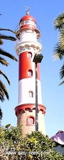
Swakopmund was founded in 1892, by Captain Curt von François.On 4 August 1892 the crew of a gunboat named Hyäne (German for Hyena) erected two beacons on a large dune, probably in the vicinity of the present lighthouse. This is regarded as the founding date of Swakopmund. 
15 Jan 09
anonymous