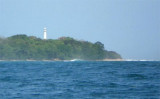
Le détroit de la Sonde, en indonésien Selat Sunda, est un détroit séparant les îles indonésiennes de Java et Sumatra.
2010/01/28
Mettre à jour
Anonymous
The Sunda Strait (Indonesian: Selat Sunda) is the strait between the Indonesian islands of Java and Sumatra. It connects the Java Sea to the Indian Ocean.
Tg Balimbing (Belimbing) is the S point of Teluk Balimbing and the NW entrance point of Selat Sunda. The coast is generally low and densely overgrown, but inland the country is mountainous.Teluk Balimbing indents the coast just N of Tanjung Balimbingpamancasa. The village of Balimbing ...
Pulau Batu Kecil lies about 7 miles WNW of Tanjung Balimbingpamancasa; it is low, wooded,about 0.7 mile in extent, and surrounded by a reef. A shoal bank extends NW and SE of the island.
Ujung Cukubatuberagam the, S extremity of the bay, is fringed by a coral reef; a 3.6m patch lies 0.5 mile N of the point and a shoal, upon which there is a rock with a depth of 0.6m, lies 1.5 miles NNW of the point. The coast from Ujung Cukubatuberagam trends about 23 miles SE ...


 hbjkbijjbh
 Le détroit de la Sonde, en indonésien
 The Sunda Strait (Indonesian: Selat Sunda) is the strait between the Indonesian islands of Java and Sumatra.