South Foreland Lighthouse is a Victorian lighthouse on the South Foreland used to warn ships approaching the nearby Goodwin Sands. It went out of service in 1988 and is currently owned by the National Trust.
South Foreland was the first lighthouse to use an electric light. By 1875 the lighthouse was using carbon arc lamps powered by a steam-driven magneto.
The White Cliffs of Dover on the English coast are one of the most well known English landmarks. They can be seen from Calais and from the Channel. They hold a special value in English history.
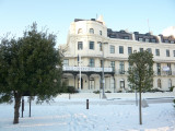
ROYAL CINQUE PORTS YACHT CLUBDon't neglect to visit the Royal Cinque Ports Yacht Club when in Dover. We are situated on the harbour front with outstanding views of the harbour from the terrace. The club is only 5 minutes' walk from the marinas, and we welcome visiting ...
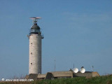
Ce phare, mis en service en 1957, est constitué d'une tour cylindrique de pierres apparentes. Son feu blanc est à 72 mètres au-dessus de la haute mer. Sa portée est de 29 NM.