Selat Cincin is the channel 4 miles wide between the S end of Ko Tarutao and the N coast of Pulau Langkawi.
The channel trends SE around the NE side of Pulau Langkawi and is bounded on the NE side by the coastal bank off the coast of Thailand.
Tides—Currents.—The tidal currents in Selat Cincin are irregular
and influenced by the monsoons. During the Northeast Monsoon rates of 2
knots setting WSW have been experienced.
Depths in the channel are regular, shoaling gradually ENE and towards each side, with depths of over 18m in the fairway.
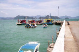
Pulau Tuba (5 km S of Langkawi) is the only inhabited island besides the main island of Langkawi itself. This Langkawi island gets its name from the tuba roots.
It is the only other island that offers accommodation and there are a few places to stay. At Pulau Tuba, you can experience ...
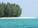
Koh Tanga and Koh Chuku, halfway between Butang and
Tarutao offer great snorkelling, diving and fishing. The best anchorage is found on the east or west coasts
between the north and south Tangas, depending on wind
direction and ground swell. Alternative daytime anchorage
can ...
Tanjung Rhu
has 2 choices of anchorage. The outer area just after entering the bay from the northern channel is fairly restricted for where you can anchor, as a lot of it has shoals in the southern part.
It can also get lumpy if winds freshen out of the West or NW. To enter ...
Langkawi port est situé à Teluk Ewa, sur la côte N de Pulau Langkawi. Il est conçu pour gérer les produits pétroliers, du charbon et des marchandises générales. Les principales exportations comprennent ...
Located E coast of Malaysia.It's the most easterly anchorage for Langkawi. Being surrounded by a cluster of islands adds to the calm conditions in most winds, but being close to the open sea, sometimes there's a
bit of ground swell to contend with. The water is clean ...


 Selat Cincin is the channel 4 miles wide between the S end of Ko Tarutao and the N coast of Pulau Langkawi.