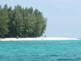

Pulau Tuba (Langkawi)
12nm
155°
At Pulau Tuba, you can experience ...
27 Nov 11
Jojo
| Latitude | Longitude | |
| DMS | --- | --- |
| DM | --- | --- |
| DD | --- | --- |

")
Ebook | Andaman sea
|
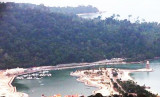
 Langkawi port est situé à Teluk Ewa, sur la côte N de Pulau Langkawi.
")
 Langkawi port is situated at Teluk Ewa, on the N side of Pulau Langkawi.
The port is entered through a channel marked with buoys and lighted buoys.
The seaward end of the channel is marked with a lighted buoy.
From W to E the port offers 4 berths, which are the Petronas Jetty, Main Jetty, Sub Jetty, and
Lada’s Barter Trade Jetty.
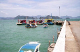
Pilotage.—Pilotage is compulsory and available 24 hours.
The pilot boarding station, best seen on chart, is situated about 1 mile WNW of Pulau Dangli.
Regulations.—The vessel’s ETA should be sent as soon as possible advising arrival draft, date, and time. Further ETAs should be sent 10 days, 5 days, 3 days, 2 days, and 1 day priorto arrival.
Anchorage.—Vessels calling on the port may request to use the designated anchorage areas situated E of the pilot station.
Phone : 04 9594600
Fax : 04 9594598