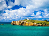
Faro Los Morrillos de Cabo Rojo, also known as Los Morrillos Light.
Located at the southwestern tip of the island of Puerto Rico, this lighthouse was constructed in 1882 in order to guide passing ships through the southeast entrance from the Caribbean Sea through ...
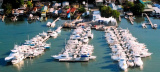
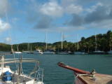
Puerto Real , If you're a "2000boats crowed marina" 's fan you could be a little disappointed here. First fishing settlement of the island, the bay is very well protected and your boat will be safe, and it's so beautiful there : painted houses with wooden pier, pelican and fregatas Puerto ...
The old city of San Juan is magical. With an old fort high on a cliff overlooking the port entrance, the blue brick cobblestone styled roads, and the alleys of beautiful restaurants and shops our eyes are spoiled from the beauty of it all.
La fosse de Milwaukee est la partie la plus profonde de l'océan Atlantique, avec une profondeur maximum de 8605 mètres et fait partie de la fosse de Porto Rico. Son emplacement est 19°35'N, 066°30'W, à 135 kilomètres au nord de la côte de Porto Rico. Cet endroit du fond océanique ...


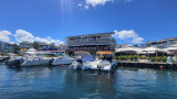


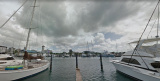
 Port de commerce protégé par une digue.
 Harbor protected by a breakwater.