


False point (Orissa-NE India)
4.3nm
56°
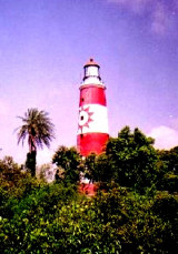
The lighthouse on the point is shown from a white round masonry tower with red bands; the lighthouse is difficult ...
21 Apr 12
Jojo
| Latitude | Longitude | |
| DMS | --- | --- |
| DM | --- | --- |
| DD | --- | --- |
 channel 6, 9, 12, 16


 Paradip lies on the coast about 6.5 miles ENE of the entrance of the Jatadharmhan River.
 The port is approached through a channel with dredged depth of 12.8m. Vessels with a draft of 13m can utilize this port, which offers problem-free berthing year round. Berth information is given in the accompanying table.
LASH operations are normally carried out between the mother ship at the anchorage and the lighter berths at the S end of the general cargo wharf.
The port has a large turning basin 520m in diameter, with a dredged depth of 12.8m.
Paradip Light is shown from a round concrete tower, 1.5 miles W of the entrance to the port. The entrance to the port is protected by a N and a S breakwater. A trestle pier projects from the S breakwater.
The channel leading into the inner harbor passes about midway between two breakwaters and then extends NW to the turning basin close SW of the T-head jetty on the E side of the harbor. The alignment of the main fairway is indicated by two pairs of range lights.
Pilotage is compulsoryfor all vessels greater than 200 gross tons and is available 24 hours. Pilots board 2 miles SE of the harbor entrance.
Departing vessels should reuest a pilot from Port Control on VHF channel 16 at least 2 hours prior to departure.
Vessels should send their ETA 24 hours in advance.
The following information should be sent by radio when a vessel is within 40 to 60 miles to the port:
1. Vessel’s name.
2. Last port of call.
3. ETA.
4. Gross tonnage.
5. Length overall.
6. Breadth.
7. Draft.
8. Deadweight tonnage.
9. Speed.
10. Dangerous cargo.
11. Type and quantity of cargo.
12. Name of agent and requirements.
Storm and weather signals are shown at Paradip; the General System is used.
Port Control can be contacted, as follows:
1. Call sign: Paradip Port
2. VHF: VHF channels 6, 9, 12, and 16
3. E-mail: pptinet@dte.vsnl.net.in
The harbormaster can be contacted, as follows:
1. Telephone: 91-6722-222012
2. Facsimile: 91-6722-223498
3. E-mail: harbourmaster_ppt@email.com
An SPM has been established about 10 miles SE of the
entrance to the Jatadharmohan River. A submarine pipeline extends from
the SPM to a point on the coast about 4.5 miles WSW of the entrance to
Paradip Harbor.
Anchorage areas for VLCCs, each with a radius of 1.5 miles, are centered about 4.5 miles S and about 5.5 miles ENE of the SPM. Anchorage is prohibited within 2 miles of the SPM and within 1 mile of the submarine pipeline.
The low coast extends about 3 miles ENE and terminates at the Lion’s Rump, on the S side of the entrance of the Mahanadi River.
A conspicuous white house and a water tower stand about 0.5 mile SW of the Lion’s Rump.
") Paradip lighthouse
Paradip lighthouse") Paradip port
Paradip portEbook | Bay of Bengal
|


