Localisation
Luanda
Latitude Longitude DMS --- --- DM --- --- DD --- ---
Caractéristiques
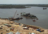
Commercial Port
Description
La ville fut fondée en 1575 par les Portugais sous le nom de São Paulo de Luanda et fut le centre administratif de la colonie d'Angola depuis 1627.
2009/01/15
Mettre à jour
anonymous
Porto de Luanda was founded by Paulo Dias de Novais in 1575 and settled by Portuguese colonists. It is the second busiest seaport in Angola.
2009/01/15
Mettre à jour
anonymous
Partagez vos remarques ou photos sur "Luanda"
Sites autour de LuandaFlying distances - Direct line
Port de Banana
Kipundji
Lobito
Sea-Seek Guide Nautique Durant vos navigations, pensez à mettre à jour les données. Si un port, une marina ou un mouillage manque, crée le. Merci pour tous les plaisanciers.


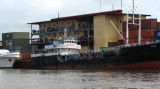

 Commercial Port
 La ville fut fondée en 1575 par les Portugais sous le nom de São Paulo de Luanda et fut le centre administratif de la colonie d'Angola depuis 1627.
 Porto de Luanda was founded by Paulo Dias de Novais in 1575 and settled by Portuguese colonists. It is the second busiest seaport in Angola.