From Kuala Selangor to abreast the N end of Selat Kelang Utara (Kelang Strait), about 18 miles S, the coast is low, densely wooded, and flooded in most parts at HW.
It is fringed by a mud bank, which dries, extending about 1 mile offshore, gradually closing the coast at the S end.
The N approach is bounded on the W side by Angsa Bank, which extends 25 miles in a NW direction from Pulau Kelang, and on the E by the extensive mud bank with rocks above water in places, fronting the coast S of the Sungai Selangor. Discolored water marks the edges of these banks. Approaching ...
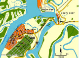
Selat Kelang Selatan, the S entrance to Selat Kelang Utara, lies between Pulau Lumut on the E side and Pulau Pintu Gedung, Pulau Che Mat Zin, and Pulau Kelang on the W. Its narrowest part is under 0.5 mile wide abreast of Pulau Che Mat Zin. The S approach has a dredged to a depth ...
Angsa Bank North Cardinal Light Float is moored off the NW end of Angsa Bank, about 15miles W of Kuala Selangor Light. The bottom is soft and not likely to damage a vessel touching, and the water is invariably smooth. From a position about 12 miles W of Kuala Selangor light, a ...
Port Klang is the principal port in Selangor. It also serves as the port for the Klang Valley, Malaysia's most developed region where the capital Kuala Lumpur (that lies 40 miles to the E) is located. The port is situated on the W coast of the Malaysian Peninsula at the N end ...
Pyramid Shoal, which lies on the N side of the SE end of South Sands, has a least depth of 3.4m, hard sand, and is the most dangerous shoal in the area because of its depth and protrusion into the fairway. A lighted buoy is moored about 7 miles SE of Pyramid Shoal. A depth of about ...
Selat Lumut separates the E side of Pulau Lumut from the mainland. It has a least width of about 0.1 mile, with both sides of the S entrance fringed by mud banks. Selat Lumut has not been surveyed in detail, but appears to be navigable by vessels of not more than 3m draft. From ...


 From Kuala Selangor to abreast the N end of Selat Kelang Utara (Kelang Strait), about 18 miles S, the coast is low, densely wooded, and flooded in most parts at HW.