Hope Island (Andhra Pradesh-E India)
4.5nm
113°
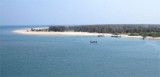
The area between Kakinada coast and Hope Island is known as Kakinada ...
28 Mar 12
Jojo
| Latitude | Longitude | |
| DMS | --- | --- |
| DM | --- | --- |
| DD | --- | --- |


")
Ebook | Bay of Bengal
|
 The port of Cocanada comprises a partly-exposed anchorage located about 3 to 4 miles NNE of the entrance of the Cocanada River and is suitable for ocean-going vessels; cargo is transported by lighters between the anchorage and the wharves on the river bank abreast of the town.
Tidal current effects are noticeable nearly 0.5 mile off Godavari Point. The current follows the contour of the land, with the flood current having a maximum velocity of 0.5 knot and the ebb current having maximum velocities of 1.5 to 2 knots.
Depths in the dredged buoyed channel leading to the barge facilities on the banks of the Cocanada River average about 2.1m. Depths alongside the lighter wharves range from 1.2 to 2.1m.
Deep Water Port is 610m long, with an alongside depth of 10m. It consists of two multi-purpose berths and one liquid cargo berth. Vessels up to 190m long, with a maximum beam of 32.4m and a maximum draft of 11.5m at HW, can be accommodated.
Lighterage Area M1, which has been designated for lighterage operations, has a radius of 1 mile centered on a position about 7.5 miles ESE of Goadaveri Point, as seen on the chart.
A designated anchorage for vessel awaiting lighterage operations lies about 3 miles NW of Lighterage Area M1 and is also best seen on the chart.
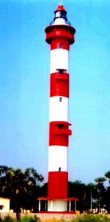
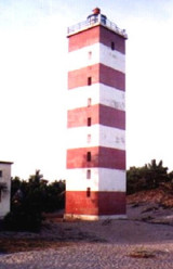
In the approach to the port, the disused lighthouse on Hope Island, Godavari Point Light, and Vakalapudi Light are conspicuous landmarks.
Pilotage is compulsory for all vessels using Deep Water Port. The vessel’s agent makes the request for pilotage 72 hours prior to arrival. The pilot station can be contacted on VHF channel 14 or 16.
Pilotage is not required for vessels calling at the Anchorage Port.
Vessels using the Anchorage Port should advise their agent of their ETA. Vessels should also obtain bearing position from the harbormaster to ensure safe anchorage in the Anchorage Port.
A signal station is located at Vakalapudi Light.
Vessels can communicate with the station by Morse code.
The port can be contacted, as follows:
1. VHF: channels 12, 14, and 16
2. Tel: 91-884-2365089 or 91-884-2365889
3. Fax: 91-884-2385402
4. Mail: mailkkd@kakinadaseaports.in
Anchorage in the bay, E of Vakalapudi Light, issubject to considerable ground swell from the SE, even when there is no wind. Anchorage may be obtained 2.25 miles ESE of Vakalapudi Light, in a depth of about 9m. Safe anchorage may also be obtained, in a depth of about 6m, about 3.25 miles SE of Vakalapudi Light. There is very little tidal current at these anchorages.
Vessels are advised not to anchor between 1 mile and 1.8 miles N and NW of Godavari Point Light, because of the numerous wrecks which lie in this area. Some of these wrecks are dangerous to surface navigation.
There is a foul patch about 0.4 mile NNW of the point, with dangerous wrecks within 0.5 mile N of the foul patch. Other foul areas, best seen on the chart, lie NNE and NE of Godavari Light.
Extensive developments, including the construction of wharves and breakwaters and the establishment of dredged areas and dumping grounds, have taken place in Cocanada Bay.
Depths may also be less than charted.