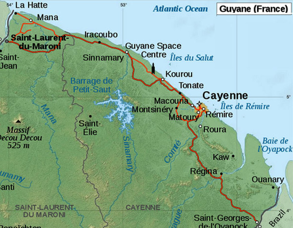
The coast of French Guiana between the Maroni River, the W boundary, and Fleuve Oyapock, the E boundary, is generally low and is seen as a dark line of mangroves. A number of hills rise in the background and can be seen for some distance offshore. The coast of French Guiana extends for about 170 miles and is affected
by outflow from all its main rivers.
The coastal bank extends a considerable distance offshore. The coastal bank lies as far as 21 miles offshore. Vessels should proceed with caution as the coastal reef has been reported to extend from 1 to 9 miles farther offshore than charted.
On the north Atlantic coast of South America, It borders Brazil to the east and south, and Suriname to the west.
The coastal bank extends up to 25 miles offshore. There are no sheltered harbors for large ships. Ships of limited draft can proceed to Georgetown on the Demerara River and to New Amsterdam on the Berbice River, but must cross the bars of these rivers and engage pilots.
The capital Georgetown is a dirty, bustling port with no facilities for
yachts. On the right bank of the river Demerara, the town has nineteenth
century houses on stilts and boulevards built along disused Dutch
canals. Seawalls and dykes protect the town, which is built on an
alluvial flat area below the highwater mark. If electing to anchor in
the Demerara River the yacht should not be left unattended.
As in many South American countries, armed robbery and violent crime
does occur. The UK Foreign Office recommend exercising caution when
travelling in Guyana, however most visits are trouble-free. The local
authorities have been working hard over the last few years to improve
the security situation for visiting yachts and are keen to develop
yachting tourism.
Georgetown is notorious for petty street crime. Do not walk alone at night, or even during the day.
The climate is hot and humid, especially from August to October. The wet
seasons are from April to August, and November to January. Guyana lies
outside of the hurricane belt.
Tradewinds exist in the area practically
all year. From January to April winds are predominately out of the northeast;
from April to December east and southeast. The north equatorial current,
with speeds between one and three knots, has maximum effect between 60
and 100 miles offshore. The tidal current, with a speed of around one-and-a-half
knots, runs along the coast and is stronger in front of the river mouths.
Formalities on arrival are straightforward and free of charge. The
official port of entry is Degrad de Cannes (4°51'N, 52°16'W) in
the river Mahury. It is also possible to register with the authorities
in Kourou. Valid passports and ship's papers are required.
2016/01/21
Mettre à jour
Joëlle


 La Guyane est une région et un département français situé en Amérique du Sud, limitrophe du Brésil au sud-est et au sud, et du Suriname à l'ouest. Les compétences de ces deux niveaux de collectivité sont exercées dans le cadre d'une collectivité territoriale unique dont l'organe délibérant est l'assemblée de Guyane. Hors de France, la région est parfois appelée Guyane française. Avec une superficie de 83 856 km2 et une population de 296 711 habitants (2019), la Guyane est la deuxième région de France pour la superficie et la deuxième moins peuplée (après Mayotte). C'est également le département le plus boisé, 97 % du territoire étant couvert d'une forêt équatoriale qui reste parmi les plus riches et les moins écologiquement fragmentées du monde, la forêt guyanaise.
 The coast of French Guiana between the Maroni River, the W boundary, and Fleuve Oyapock, the E boundary, is generally low and is seen as a dark line of mangroves. A number of hills rise in the background and can be seen for some distance offshore. The coast of French Guiana extends for about 170 miles and is affected
by outflow from all its main rivers.


