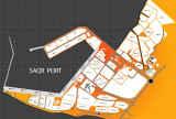
Mina Saqr (Ras al Khaimahi) est un port artificiel construit dans une eau profonde. Les limites du port comprennent Khawr Khuwayr (Hanna). Les cargos, ciment en vrac, conteneurs et rouliers, et les produits pétroliers sont traitées dans le port. Profondeurs-Limitations.-Les
...
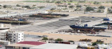
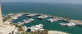
Al Jazira port fronts Jazirat al Hamra, which was once an island but is now part of the mainland. The port exports rock and aggregates from nearby quarries but can also handle bulk, liquid, ro-ro, container, and general cargo.Tides—Currents.—The mean maximum ...
Khor Fakkan (or Khawr Fakkan) is a town located along the Gulf of Oman on the east coast of the United Arab Emirates (UAE). The town is set on the picturesque bay of Khor Fakkan, which means "Creek of Two Jaws". Khor Fakkan belongs to the emirate of Sharjah but is geographically ...
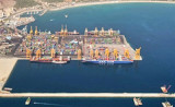
Port of Fujairah (or Fujayrah) is the only multi-purpose port on the Eastern seaboard
of the United Arab Emirates, approximatly 70 natuticak miles from the
Straits of Hormuz. Initial Construction of the Port started in 1978 as
part of the economic development of the UAE. Full ...


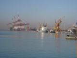


 Port de commerce protégé par une digue.
 Harbor protected by a breakwater.