Mina Saqr Port (Ras Al Khaimah)

Mina Saqr Port (Ras Al Khaimah)

Pour géolocaliser ce lieu. Mettre à jour si besoin.

Localisation

Mina Saqr Port (Ras Al Khaimah)
LatitudeLongitude
DMS------
DM------
DD------

Caractéristiques

Gasoil
Car Park
Supermarché
Restaurant
Banque
Port de commerce

Description

Mina Saqr (Ras al Khaimahi) est un port artificiel construit dans une eau profonde. Les limites du port comprennent Khawr Khuwayr (Hanna). Les cargos, ciment en vrac, conteneurs et rouliers, et les produits pétroliers sont traitées dans le port.
Profondeurs-Limitations.-Les navires jusqu'à 60 000 tpl, avec une longueur maximale de 200m et un tirant d'eau maximal de 11,5 m, peuvent être accueillis.
8 places en eau profonde, n ° 1 à n ° 7 et n ° 9, ont des longueurs de 150 à 200 m et des profondeurs de 12.2m. Les approches internes sont draguées à une profondeur de 12,2 m.
Le bassin principal est dragué à une profondeur de 12,2 m.

Aspect-
La digues protégeant le port porte des radars remarquables. Il ya deux éminents silos gris-argent dans les environs du port. Deux cheminées remarquables de l'usine de ciment se trouvent à 1 mile à l'ESE de la zone portuaire.
Une torche se trouve à proximité de la côte à 2 miles au S de l'entrée du port. Elle est visible à une certaine distance au large. Deux réservoirs d'huile s'élèvent au S, proche de la torchère.
Un feu de secteur, menant à l'entrée du port, se dresse sur le brise-lames S.
Un voyant rouge qui clignote dans le voisinage du feu de secteur, indique que des hélicoptères opèrent à partir d'un héliport à proximité.

Pilotage.-
Le pilotage est obligatoire et est disponible 24 heures.
Contacts-Information.
L'autorité portuaire peut être contacté directement, comme suit:
1. Téléphone: 971-7-2668444
2. Télécopieur: 971-7-2668533

3. E-mail: mspamis@emirates.net.ae
       info@saqrport.com

La tour de contrôle peut être contactée directement, comme suit:

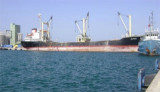
1. Indicatif d'appel: Saqr Port Authority
2. VHF: canaux VHF 14 et 16
3. Téléphone: 971-7-2668051
Le pilote monte à environ 2 miles N de la tête de la digue ouest.
Regulations.-
Le navire ETA doit être envoyé à l'agent du navire ou de la capitainerie 48 heures à l'avance, indiquant la longueur du navire, le projet, et tous les détails de la cargaison.
Contactez-Port de contrôle sur le canal VHF 16 d'au moins 2 heures avant l'arrivée.
Les navires au mouillage doivent écouter en permanence le canal VHF 16.
Anchorage.-
Trois zones de mouillage désignées sont situées au NW de l'entrée du port et sont réservées à une utilisation, comme suit:
1. Anchorage Zone I-pour les navires de moins de 50m loa, les barges et les petites embarcations.
2. Anchorage Zone II-pour les navires de plus de 50m loa.
3. Anchorage Zone III-pour les navires de soutage seulement.

Attention.-
Les pipelines s'étendent au N et NW du rivage SW proches de la Khawr al Khuwayr.
La prudence est de rigueur lors de l'utilisation du mouillage de la Zone I comme une obstruction, elle est marquée au N et au S par des bouées lumineuses, et est située dans le centre de la zone.
2011/09/23
Mettre à jour
Jojo
Mina Saqr (Ras al Khaimahi) is an artificially-constructed harbor with deep water. The port limits include Khawr Khuwayr (Hanna). General cargo, bulk cement, container and ro-ro cargo, and petroleum products are handled in the port.

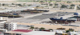
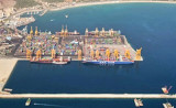
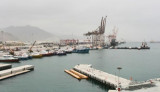
Depths—Limitations.—Loaded vessels up to 60,000 dwt, with a maximum length of 200m and a maximum draft of 11.5m, can be accommodated.
Eight deep-water berths, No. 1 through No. 7 and No. 9, have lengths of between 150 to 200m and depths alongside of 12.2m. The inner approaches are dredged to a depth of 12.2m.
The main basin is dredged to a depth of 12.2m.
Aspect.—The breakwaters protecting the port are reported to be radar conspicuous. There are two prominent silver-grey silos in the vicinity of the harbor. Two conspicuous chimneys rise from the cement factory 1 mile ESE of the harbor area.
A prominent flare stack stands near the coast 2 miles S of the harbor entrance. It is reported to be visible for some distance offshore. Two oil tanks stand close S of the flare stack.
A sector light, leading through the harbor entrance, stands on the S breakwater.
A red warning light, which flashes in the vicinity of the sector light, indicates helicopters are operating from a nearby heliport.
Pilotage.—Pilotage is compulsory and is available 24 hours.

Contact Information.—The port authority can be contacted, as follows:
1. Telephone: 971-7-2668444
2. Facsimile: 971-7-2668533
3. E-mail: mspamis@emirates.net.ae
   info@saqrport.com
The control tower can be contacted, as follows:
1. Call sign: Saqr Port Authority
2. VHF: VHF channels 14 and 16
3. Telephone: 971-7-2668051
The pilot boards about 2 miles N of the head of the W breakwater.

Regulations.—
The vessel’s ETA should be sent to the vessel’s agent or the harbormaster 48 hours in advance, stating the vessel’s length, draft, and full details of cargo.
Contact Port Control on VHF channel 16 at least 2 hours prior to arrival.

Vessels at anchor should maintain a continuous listening watch on VHF channel 16.

Anchorage.—Three designated anchorage areas, best seen on the chart, are located NW of the harbor entrance and are designated for use, as follows:
1. Anchorage Zone I—for vessels less than 50m loa, barges, and small craft.
2. Anchorage Zone II—for vessels greater than 50m loa.
3. Anchorage Zone III—for bunkering vessels only.
Caution.—Pipelines, best seen on the chart, extend N and NW from the shore close SW of the Khawr al Khuwayr.
Caution is necessary when using Anchorage Zone I as an obstruction, marked N and S by lighted buoys and best seen on the chart, is located in the center of the area.

2011/09/23
Mettre à jour
Jojo
Mina Saqr Port (Ras Al Khaimah)
2011-09-23
Mettre à jour
Jojo
Ebook

Persian Gulf - Arabian Gulf

  • 61 sites
  • 71 photos
  • publication date: 7 Jul 2023
  • .pdf file size: 37 Mb
Partagez vos remarques ou photos sur "Mina Saqr Port (Ras Al Khaimah)"

Sites autour de Mina Saqr Port (Ras Al Khaimah)

Flying distances - Direct line

Al Jazeera Port (Ras Al Khaimah)

20nm
220°
Al Jazira port fronts Jazirat al Hamra, which was once an island but is now part of the mainland.
The port exports rock and aggregates from nearby quarries but can also handle bulk, liquid, ro-ro, container, and general cargo.Tides—Currents.—The mean maximum ...
10 Oct 11
Joëlle

Khwr Umm Al Qaywayn port

35nm
227°
Khawr Umm Al Qaywayn is an old natural coastal harbor  located in the old town overlooking the traditional dhow building yard where skilled craftsmen continue to assemble these traditional boats. The harbor is surrounded by old coral stone houses that ...
10 Oct 11
JB Antibes

Khor Fakkan port Sharjah

40nm
155°
Khor Fakkan (or Khawr Fakkan) is a town located along the Gulf of Oman on the east coast of the United Arab Emirates (UAE). The town is set on the picturesque bay of Khor Fakkan, which means "Creek of Two Jaws".
Khor Fakkan belongs to the emirate of Sharjah but is geographically ...
14 Oct 11

Al Hamriyah (Ajman)

43nm
225°
Al Hamriyah is a village about 7 miles SSW of Umm al Qaywayn. The tower of a new fort, with a flagstaff and a white minaret, are conspicuous. There is a creek at the S end of the village which connects at HW with Khawr Ajman. The creek was dredged (2004) ...
12 Oct 11
Joëlle

Fujairah Port

50nm
160°
Port of Fujairah (or Fujayrah) is the only multi-purpose port on the Eastern seaboard of the United Arab Emirates, approximatly 70 natuticak miles from the Straits of Hormuz.
Initial Construction of the Port started in 1978 as part of the economic development of the UAE. Full ...
16 Oct 11
Joëlle