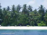
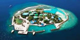
Île située au S de Malé, à 12 km. La plage est magnifique avec ses grands palmiers. Le lagon qui entoure l'île est idéal pour faire de la plongée. II suffit de passer en bateau la barrière de corail et d'approcher de Velassaru pour ressentir cette inoubliable sensation de bout du monde. Trente minutes suffisent pour rejoindre cette île paradisiaque de l'atoll Malé sud, perdue dans l'Océan Indien Sur ce bout de terre baigné par un incomparable lagon turquoise.
2008/01/4
Actualizar
Located in south male' 12 kilometres from the capital city, the laguna maldives resort a tranquil tropical setting situated among groves of coconut palms floating in the dreamy blue water of its private lagoon. The lagoon which surrounds the island is ideal for snorkelling, canoeing and windsurfing.
Funadhoo (Funidu) lies about 0.3 mile N of the E end of Male, and is surrounded by a reef which dries in places. A small tank farm, with three large and about six smaller tanks,stands on the island.
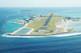
Hulule, about 0.6 mile E of Funadhoo, bears some tall coconut palms; an airstrip runs the full length of the island and joins it to an islet close S. Airport buildings and a small village lie along the central part of the W side of Hulule. The Malé International Airport is located ...
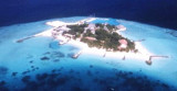
Giraavaru an islet covered in scrub and with a few coconut palms, lies on the SW side of Male Atoll, about 0.5 mile within the outer edge of the barrier reef. A small bare islet lay at the extremity of the reef extending 1 mile W of Giravaru; a similar islet lies 1 mile S of Giravaru. It's ...
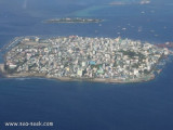
Posée sur les flots, la capitale des Maldives compte 100 000 habitants sur 2 km², soit le tiers de la population du pays. La ville est située sur l'île de Malé d'une superficie de 1,5 km² dans l'atoll de Malé (Kaafu) dans le sud de l'archipel des Maldives. Malé est depuis ...
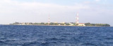
Viligili (Wilingili), a low wooded islet used as a tourist village, lies 1 mile W of Male. It is surrounded by steep-to foul ground extending up to 0.3 mile offshore. The light on the islet is reported to be a good landmark. The channel between Viligili and Male has a 5.5m shoal ...
A good, easily discernible channel, S of Giravaru, with a least depth of 48m in its center, leads through the barrier reef. A wider, less deep channel lies NW of Giravaru; a shoal patch, with a least depth of 3.4m, lies in the channel, about 0.7 mile NW of Giravaru, where it broadens ...


 Île située au S de Malé, à 12 km. La plage est magnifique avec ses grands palmiers. Le lagon qui entoure l'île est idéal pour faire de la plongée. II suffit de passer en bateau la barrière de corail et d'approcher de Velassaru pour ressentir cette inoubliable sensation de bout du monde. Trente minutes suffisent pour rejoindre cette île paradisiaque de l'atoll Malé sud, perdue dans l'Océan Indien Sur ce bout de terre baigné par un incomparable lagon turquoise.
 Located in south male' 12 kilometres from the capital city, the laguna maldives resort a tranquil tropical setting situated among groves of coconut palms floating in the dreamy blue water of its private lagoon.
")
")