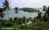
Pointe Française ou Pointe des Hattes (French Guiana)
15nm
23°
20 Jan 16
Joëlle
| Latitude | Longitude | |
| DMS | --- | --- |
| DM | --- | --- |
| DD | --- | --- |


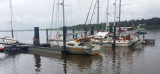
 Un site sympa très calme surtout à l'abri des intempéries. Vous tomberez sous le charme de cette ville dont l'histoire est particulièrement intéressante avec les vestiges du bagne, les nombreuses populations d'origines diverses.
Plus d'infos : eileen_of_avoca@yahoo.com
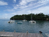
 Port NW French Guiana, on the east bank of the Maroni River opposite Albina, Suriname.
It was formerly headquarters of the country’s penal colonies and the
site of the largest prison, closed in 1944. Apart from its port
facilities, local economic activities include sawmilling, boat
repairing, and sugarcane cultivation.
Port NW French Guiana, on the east bank of the Maroni River opposite Albina, Suriname.
It was formerly headquarters of the country’s penal colonies and the
site of the largest prison, closed in 1944. Apart from its port
facilities, local economic activities include sawmilling, boat
repairing, and sugarcane cultivation.For clearance, visit the PAF (police aux frontières ) at the car ferry to have your passport stamped (entry and exit). Not obligatory for European citizens, but prevents issues when your next stop is Suriname.
Customs (la douane) is in the administrative centre.
A buoyed channel for cargo vessels marks the route. Following the latest survey of the Maroni River, the minimum depth at high tide is over 4m.
Beware of fishing nets when approaching the Maroni river's safe water mark.While night entry is possible, it is not recommended as buoys closer to Saint Laurent are not lit.
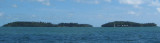
Anchorage.—Sheltered anchorage can be taken about 0.5 mile N of Pointe Panato, about 2 miles SSW of Pointe Francaise, in 7 to 8m, mud.