Le peu de fonds autour des iles est favorable aux catamarans. 2007-02-10°
2007-07-11
Actualizar
Mobile
On peut venir aussi en monocoque, tirant d'eau 1.80 m, sans soucis...
2016/01/20
Actualizar
phil de tudo bem
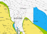
Anchorage can be taken in the bight formed by the S side of Ile Royale in depths of about 9m soft mud, good shelter from the swell, and good holding .ground.
Caution: Alouette Bank, covered with 4.8m of water, lies about 1.7 miles NNW of Ile Royale. Depths of 3.5 to 5.5m lie between Ile Royale and this bank. An isolated 6.1m shoal lies 0.5 mile W of Ile Royale.
2016/01/20
Actualizar
Joëlle
Comparta sus comentarios o fotos en "Ile Royal (French Guiana)"
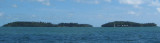
Îles du Salut, 3 in number, are located about 7 NM NE of Pointe Charlote.Ile du Diable, the northernmost, is 40m high. Ile Royale, 66m high, is the largest and westernmost, while Ile Saint-Joseph, only 30m high, is the southernmost.
Île du Diable part of Salut islands is better known as Devil's Island. The total area is 0.62 km2 (62 hectares) The islands were used as a penal colony from 1852 onwards, earning them a reputation for harshness and brutality. This system was gradually phased out and has been completely ...
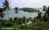
Un site sympa très calme surtout à l'abri des intempéries. Vous tomberez sous le charme de cette ville dont l'histoire est particulièrement intéressante avec les vestiges du bagne, les nombreuses populations d'origines diverses.Plus d'infos : eileen_of_avoca@yahoo.com
Cabo Orange (cape Orange) is a cape on the N coast of Brazil, separated from the coast of French Guiana by a large bay watered by the estuary of the Oyapock River Cape Orange is the northernmost point of the Brazilian state of Amapá. It is located in an area of tidal marshland protected ...


") Le peu de fonds autour des iles est favorable aux catamarans.
Le peu de fonds autour des iles est favorable aux catamarans. On peut venir aussi en monocoque, tirant d'eau 1.80 m, sans soucis...
 Anchorage can be taken in the bight formed by the S side of Ile Royale in depths of about 9m soft mud, good shelter from the swell, and good holding .ground.