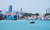
Pinang Harbor is one of Malaysia’s largest ports and handles most of the trade for the cultural, industrial, and agricultural regions of Northern Peninsular Malaysia.
The port complex includes facilities on Pulau Pinang at Georgetown and on the mainland at Butterworth and Perai (Prai).
Pinang Harbor has ample, modern, alongside berthing facilities for all classes of vessels.
NAVIGATIONAL
APPROACH:
a.
North Channel Light Float in position Lat 5 (35.9' N. Long 100 12.45' E) for vessels entering the harour through the North Channel.
Vessels awaiting Pilot can anchor at North Channel, in the pilot waiting area.
b.
For entry through the South Channel the Pilot will be taken on board in vicinity of Rimau Wreck Buoy 1.6km South of Pulau Rimau Lighthouse.
Approach through the South Channel is restricted to vessels of 28m air draft - due to existence of the Penang Bridge. Current depth 5.8m
ACD.Winds/Weather: Pinang Harbor is subject to both the Northeast Monsoon and the Southwest Monsoon, with high temperature, humidity, and rainfall throughout the year.
Winds are generally light or moderate in both seasons. The usual weather pattern is for partly cloudy mornings inland with showers and thunderstorms by the middle of the afternoon and dispersing at night.
Sumatras, which are nighttime squalls with violent thunder, lightning, and rain, can be expected from April to November with an average occurrence of about 3 to 4 per month.Tides/Currents: At springs, the tidal currents run at a rate of from 2 to 3 knots through the harbor anchorages (although rates of up to 5 knots have been observed), but less in the approaches, and continue to flow N or S for about 1 hour to 1 hour 30 minutes after LW or HW.
During the Northeast Monsoon, the tidal currents are regular; the S current runs from about 4 hours before to about 2 hours after HW by the shore, with the N current running during the remaining period. Off the entrance to North Channel a S current of 0.5 knot has been experienced. In November, the current sets round Muka Head (5°29'N., 100°11'E.) and overcomes the outgoing current, sometimes for 2 or 3 days.
The main ship channel into Pinang Harbor is via North Channel, which is 10 miles in length, has a width of 183m, and a least depth of 10.2m. Approaches to the harbor are well marked by navigational aids. Approach depths gradually increase from 11 to 22m in the area S of Buoy Tokong.
Depths—Limitations.—Shoaling to a least depth of 9.7m has been reported in some areas of North Channel. The approach to Pinang Harbor via South Channel is restricted to vessels with a 6m draft and a height of 28m due to the vertical clearance of the Pinang Bridge. A least depth over the bar of South Channel is 5.8m.
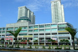
Pinang is equipped with modern wharves, piers, and basins to handle practically any cargo that can be transported on water.
These include facilities for container, ro-ro, dry and liquid bulk carriers, general cargo, and passenger vessels.
Swettenham Pier is situated on Pinang Island. The T-berth has a total length of 366m, with a depth alongside of 10m. A berth of 46m, depth 3m alongside, is situated on the W side of the S end of Swettenham Pier and is use by lighters and fishing vessels. This area is referred to as the Lighter Basin. Swettenham Pier handles break-bulk cargo, as well as passenger and naval vessels. Just S of Swettenham Pier is the Church Street Pier; further S is the ferry terminal.
Less than 1 mile E of Swettenham Pier, across the Selat Utara, is the North Butterworth Container Terminal. The Tshaped pier is 600m in length, with a depth of 12m alongside.
Less than 1 mile S of the North Butterworth Container Terminal are the Luar Shell Pier, the Bagan Luar Esso Pier, and the Butterworth Deep Water Wharves. A ferry terminal is situated between the Esso Pier and the Butterworth Deep Water Wharves.The Butterworth Deep Water Wharves are made up of six numbered berths. Berth 1 through Berth 3, used for conventional cargo, have a length of 549m and depths of 9m alongside.
Container facilities are situated at Berth 4 through Berth 6, with a total length of 497m. Berth 6 is also equipped with a ro-ro ramp of 8m wide and 28m long.
The Palm Oil Tanker Berth (Berth 9) with a depth of 8.9m is situated just S of Butterworth Pier No. 1; vessels up to 167m in length can be accommodated.
The entrance to the Sungai Perai is located S of Berth 9. On the S bank of the river entrance is the Perai Wharf. This wharf is 840m in length and suitable for coasters and lighters carrying bulk cargo. The wharf is connected to railways.
The Caltex Pier (Berth 10) consists of a mooring pontoon and berthing dolphins 0.5 mile offshore. The berth has a depth of 10m and is connected to the prominent oil tanks to the NE by an underwater pipeline.
A Bulk Cargo Terminal, for both liquid and solid cargoes, is situated at Perai. The terminal consists of two main berths 338m long with a depth of 10m alongside and one inner berth with 154m long with a depth of 7m.
Vessels of more than 5m in height or 30m in length must obtain written permission from the Port Officer, Pinang, before entering the restricted area.Aspect.—The coast of the mainland being low does not show up well from North Channel as that from Pinang Island, consequently the latter will usually appear nearer when in the fairway between them. Within the harbor limits of Pulau Pinang, Fort Cornwallis, with a conspicuous flagstaff, 5.7m high lies on the NW entrance to the harbor. On the mainland, two conspicuous radio masts lie on the E entrance of the harbor.
Numerous other prominent buildings and masts stand on the island and mainland.
Pilotage.—Pilotage is compulsory for vessels 200 grt and over when berthing and unberthing in the harbor, except fishing vessels. Vessels should send their ETA 3 hours in advance to Pilots Pinang, stating their ETA at North Channel Light Float or, in the case of South Channel, their ETA at Pulau Rimau.
The maximum draft of the vessel should also be included. Pilot should be contacted on VHF channel 12.
For vessels entering the harbor through North Channel, the pilot boarding area is NW of the North Channel Light Float. For entry through South Channel, the pilot will be embarked in the vicinity of Rimau Buoy.Anchorage.—Anchoring is prohibited within the indicated cable area on the NE side of North Channel.
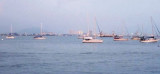
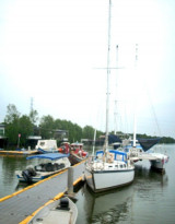
Numerous anchorages including Naval Anchorage, Petroleum Anchorage, Quarantine Anchorage, Local Anchorage, Small Craft Anchorage, and Explosives Anchorage exist within harbor limits.
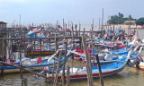
An outer anchorage is charted about 2 miles SSW of North Channel Light Float.Caution.—Fishing stakes extend all around Pulau Pinang and the mainland coast within the 10m contour line. Bamboo poles, singly or in groups, marking fishing nets or pots may be encountered in this area. Large numbers of fishing boats may be encountered in the vicinity of, and NW of Muka Head.
Mail: info@penangport.com.my
Tel: 04-210
2211
Fax: 04-263
4792


 (Malaysia)")
 (Malaysia)")