Port de Narbonne-Plage, an extensive yacht harbor, is situated 4 miles NE of Gruissan-Plage and is protected by two breakwaters. A rectangular prohibited area lies 3 miles E of the harbor entrance.
Rocher St. Pierre , located close NE of Port de Narbonne-Plage, is 5m high and surmounted by the sand-covered ruins of a battery. It is the most distinctive mark in this vicinity. A prohibited area, marked by lighted buoys, lies E of Rocher St. Pierre.
A conspicuous radar tower, 25m high, stands 3.2 miles W of Rocher St. Pierre and is surmounted by a dark green dome.
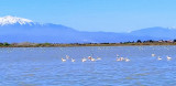
Valras-Plage, a resort, is situated at the mouth of the River Orb, 6.5 miles NE of Rocher St. Pierre. A yacht and fishing craft harbor is situated within the river mouth. A casino and a large water tower stand in this vicinity and are excellent landmarks from seaward.
Cap d’Agde , low and rocky, is located 9.5 miles ENE of Valras-Plage. Montagne du Gros Frere, 848m high, stands 29 miles N of the cape and may be sighted on a clear day from a considerable distance to the S. Mont d’Agde, 115m high, stands 1.5 miles NNW of the cape. It is isolated and conical and can easily be identified at a distance of 12 miles.
Between the cape and the mouth of the River Herault, 3 miles W, the coast is fronted by rocks and rocky points. Pointe de Roche Longue, located midway along this stretch, is surmounted by an old battery. Two radio masts stand 1 mile N of the battery and are prominent.
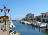
The town of Agde is situated 2 miles above the entrance to the River Herault and is fronted by depths of 3 to 6m. Small craft with local knowledge use the river.
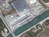
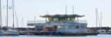
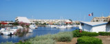
Port Cap d’Agde, a small harbor, is situated close W of Cap d’Agde. It is protected by two breakwaters and used by yachts and fishing craft.
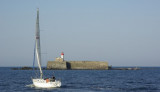
Ilot Brescou, formed by a flat rock, lies 1 mile SW of Cap d’Agde and is surmounted by the grey structure of Fort Brescou.
A light is shown from a structure, 11m high, standing at the S corner of the fort. This islet is surrounded by dangers and foul ground.
Port Amboune, a small yacht harbor, is situated 1.2 miles NNE of Cap d’Agde and is protected by two breakwaters.
Port Marseillan Plage, a small harbor, lies 2 miles NNE of Port Amboune and is protected by two jetties. A canal, with a depth of 2m, connects the harbor with Etang de Thau, a lagoon.
Quilles, a small yacht harbor, is situated 6.5 miles NE of Port Marseillan Plage. It lies on the SW side of Mont Saint Clair and is protected by breakwaters. The coast between consists of a low and narrow beach which separates Etang de Thau from the sea. A range of hills stands on the N side of the lagoon.
During W and NW winds, vessels can anchor, in 5 to 6m, sand and rock, poor holding ground, ENE of Cap d’Agde.
Several prohibited areas (fish havens), the limits of which may be seen on the chart, lie NE of Cap d’Agde and are marked by lighted buoys.
A prohibited anchorage area, marked by lighted buoys, lies about 1.2 miles SE of the harbor entrance.
The port of Sete lies 11 miles NE of Cap d’Agde and consists of three sections. An outer harbor and a series of connecting basins and canals in the N part, an industrial zone within Etang de Thau, and an offshore terminal berth.