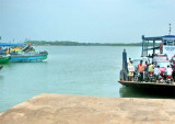

Kochi International Marina
1.3nm
57°
The Kochi Marina is the only marina in India. It's a modern all-weather port and a rapidly growing maritime gateway to peninsular India.Port Control must be contacted ...
17 Mar 12
Joëlle
| Latitude | Longitude | |
| DMS | --- | --- |
| DM | --- | --- |
| DD | --- | --- |


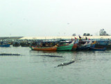
 The port of Kochi (Cochin) is a fine natural harbor formed by the estuary of the Periyar River and its backwater.
Kochi (Cochin) is outside the cyclone area, but during the Southwest Monsoon, short gusts of wind 50 to 55 knots are sometimes experienced.
The tidal rise at Kochi (Cochin) is 0.9m at MHHW and 0.8m at MLHW. Salinity within the harbor has values between 1000 and 1020, according to tidal and seasonal factors.
The maximum velocity of the ebb current at springs, throughout the year, is from 2 to 3 knots, and at neaps from 0.8 knot to 1.3 knots. The velocity of the flood current at springs, throughout the year, varies 1.5 to 2 knots and at neaps from about 0.8 knot to 1.3 knots. Both currents run for a considerable time after the predicted times of HW and LW, from 1 to 2 hours on the flood, and from 2 to 3 hours on the ebb, according to the season.
After heavy inland rains the ebb current may run continuously for many days, while the flood current enters the harbor under the surface ebb. On very rare occasions, and after high inland floods, the tidal current in the harbor may have a velocity of 5 knots or more.
In January and February, the effect of the ebb current is not noticeable W of the outer channel buoys, and no appreciable current is experienced off the coast in the vicinity of Kochi (Cochin). Under monsoon conditions, strong eddies and crosscurrents were experienced in the harbor entrance between Vypin Island and Kochi (Cochin), and also off the NW point of Willingdon Island.
On the ebb current, between the harbor entrance and the NW end of Willingdon Island, there is a strong set across the channel from the N part of the harbor; the limits of this current are marked by tide rips which cause a vessel to sheer.
The approaches to Kochi (Cochin) are clear of outlying shoals or banks, except for the shoal water of the bar, through which the deep approach channel has been dredged.
Outer Approach Channel—about 6.5 miles in length, 175m in width and maintained at a depth of 13.8m.
Inner Approach Channel—All the same as the Outer Approach Channel except that is extends to a width of 400m.
Ernakulam Channel—about 3.1 miles in length and a minimum width of 200m, dredged to a depth of 13.8m to the Cochin Oil Berths and to the Rajiv Gandhi Container Terminal, then 11m until the fertilizer berth (Q10), then 10.0m to Berths Q5 to Q7, and 9.75m to the S and N Tanker Berths.
Mattancheri Channel—about 1.6 miles in length, to a width of 183m, and maintained to a depth of 10.75m until the S end of Boat Train Pier, thence 9.75m for the remainder.
Local authorities should be consulted for prevailing depths in the channels and alongside berths. Plans are to increase the width to 260m and depths to 16.7m in the approach channel sometime in the near future.
A shoal area N of the dredged channel includes a spoil ground which is awash in places. South of the dredged channel a shoal, with a depth of less than 1.8m, and on which the sea breaks, extends about 0.9 mile W from the coast.
Vessels, once E of Fairway Lighted Buoy, must not attempt to enter or leave the approach channel without a pilot on board.
In 1985, less water than charted was found to exist outside the dredged channel on both sides. Another spoil ground lies about 2.5 miles SW of Outer Signal Station. A dangerous wreck and a small foul area lie near the N limit of the dredged channel, 1 mile E of Fairway Lighted Buoy.
Within the harbor entrance the dredged channel is about 0.2 mile wide; its N limit is marked by two lighted buoys. An anchorage for sailing vessels is situated N of the fairway, close within the harbor entrance.
The dredged channel then divides into Mattancheri Channel and Ernakulam Channel leading W and E, respectively, of Willingdon Island. A road bridge, with a lifting span, connects the SW end of Willingdon Island with the mainland W; a road and rail bridge, with a navigable opening marked by lighted dolphins, connects the E side of the island with the mainland E.
Approximately 0.8 mile SE of the fertilizer berth is Naval Jetty. Caution is necessary when berthing alongside Naval Jetty, on the W side of the channel, as the ebb current sets strongly off the pier and the flood current strongly onto it. The bar at the entrance to the harbor is dangerous for ship’s boats when the ebb tide is setting strongly against the sea breezes, resulting in a short choppy sea.
There are two mooring buoys on the E side of Mattancheri Channel which can accommodate a vessel up to 145m in length. There are also two numbered mooring buoys in the SE portion of Ernakulam Channel.
Tankers in ballast are subject to draft restrictions. Tankers less than 152.4m in length must have a minimum draft forward of 4.3m (plus or minus 0.6m and trimmed by the stern) and 4.9m aft. Minimum drafts for tankers of 152.4m and over are 4.9m (plus or minus 0.6m) forward and 6.1m aft. Additionally, tankers over 213.4m in length are subject to a maximum draft of 8.5m.
The coast in the vicinity of Kochi (Cochin) is low, sandy, and thickly fringed by palms.
A buoy, painted in red and white stripes, is moored 32 miles WNW of the entrance to Kochi (Cochin) Harbor.
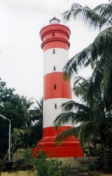
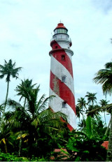
Kochi (Cochin) Light, with a racon, is shown from a concrete tower with red and white bands.
A wooden pile beacon lies 1.3 miles SSW of Kochi (Cochin) Light; a concrete pile beacon, 9.1m high, lies 1.5 miles WSW of the light.
The dredged entrance channel, Mattancheri Channel, and Ernakulam Channel are marked by lighted buoys. The harbor office, which is conspicuous, lies on the NW end of Willingdon Island. Range lights, situated N and NE of Willington Island, lead through the harbor entrance and through the center of Ernakulam Channel abreast the tanker berths.
A number of Indian Naval vessels are situated at Vendurutti (Venduruthy Island) on the E side of Willingdon Island. In this area there are several flagstaffs; a radio station, with several masts, is situated 183m NNW of the W end of the road and rail bridge.
Pilotage is compulsory for all merchant vessels over 100 grt and is advisable for smaller vessels. Pilots are available at any time. Deep-draft vessels are advised to wait for the pilot 0.5 mile W of Fairway Lighted Buoy. Pilots board vessels in position (9°57.7'N., 76°08.4'E.). The pilot vessel has a red hull with a white house. Communications with pilots is through VHF Channel 16.
Vessels may anchor in this vicinity, clear of the axis of the channel, good holding ground, mud. Vessels can enter or leave the harbor day or night at almost any state of the tide, except for crude oil tankers which may only enter by day. A vessel, equipped with radio, is stationed near the seaward end of the approach channel; it will transmit and receive messages concerning pilotage only. A vessel awaiting a pilot should, if anchoring, lie about 1 to 2 miles NNW of Fairway Lighted Buoy.
Vessels should send ETA messages 48 hours in advance to the harbormaster. Any changes in ETA should be sent at least 12 hours in advance. The message should include the ETA (in local time) at the outer roads and the salt water draft fore and aft.
Vessels should contact port control 2 hours before and 30 minutes before arrival at Fairway Lighted Buoy for pilotage and berthing instructions.
Vessels awaiting a berth should maintain a listening watch on VHF channel 16.
Immobilization of main engines is not permitted without written consent by the Port Authority. Discharge of oily water or other rubbish is forbidden.
When plague is prevalent in Northern India, vessels must obtain pratique before communicating with the shore.
Ship-to-ship transfers of liquid bulk cargo and gas are authorized in an area with a radius of 1 mile centered on position 10°03.5'N, 76°04.5'E, about 10 miles NW of the harbor entrance.
The transferring vessel should anchor in the center of the area. The vessel’s agent should notify the harbormaster in the vessel’s ETA message prior to the commencement of any transfer operations.
The Signal Station situated at the 37m flagstaff close W of Fort Cochin communicates by flags and Morse Code as necessary. Storm signals are displayed; the General System is used.
The following flags of the International Code should be displayed by vessels entering or leaving Kochi (Cochin) (meaning of hoist follows flags):
1. Q—My vessel is healthy and I request free practique.
2. Q over First Substitute—My vessel is arriving from a yellow fever port and requests health clearance.
3. G—I require a pilot.
4. H—I have a pilot on board.
5. An oil tanker should display a red ball below these flags.
A vessel must not enter harbor until the signal has been repeated by the Signal Station. Signals for vessels leaving the harbor will also be repeated by the Signal Station.
A vessel shifting berth within Kochi (Cochin) Harbor must display a black ball or shape at least 0.6m in diameter at half mast and shall proceed at not more than half speed.
The following flag signals may also be displayed:
1. EM—Vessel shifting from Ernakulam Channel to Mattancheri Channel.
2. ME—Vessel shifting from Mattancheri Channel to Ernakulam Channel.
3. DN—Port’s dredge proceeding to sea.
4. DF—Port’s dredge entering harbor.
A vessel on fire and requiring assistance should continuously:
1. Sound on it whistle or siren the letter “F” in Morse Code together with rapid and continuous ringing of the ship’s bell.
2. Hoist, by day, appropriate International Code Flag Signal (CB6, IT, etc.).
3. Telephone Port Fire Station, the Port’s Fire Float, or Harbormaster.
A vessel requiring assistance in an emergency (moorings carrying away, oil leakage, urgent medical and police assistance, etc.) may sound at frequent intervals:
1. A succession of blasts on its whistle or siren to attract attention.
2. Sound V (3 short and 1 long blast) to mean “I require assistance.”
3. Sound W (1 short and 2 long blasts) to mean “I require medical assistance.”
4. Hoist V or W of the International Code of Signals.
The port can be contacted, as follows:
1. Call sign: Kochi Port Control
2. VHF: VHF channels 14 and 16
3. Telephone: 91-984-7049056 (mobile)
91-484-2667105
4. Fax: 91-484-2668163
5.Mail: mail@cochinport.com
Anchorage is available off the port of Kochi (Cochin), in 14.5m, with Kochi (Cochin) Light bearing 075°, 4.5 miles. During the Southwest Monsoon, the best anchorage, with good communication with Kochi (Cochin), is about 2 miles NNW of Fairway Lighted Buoy.
Vessels approaching Kochi (Cochin) should keep in depths of not less than 11m and W of Fairway Lighted Buoy. When in this position, hoist the signal for a pilot and await the pilot’s arrival. The outer channel was dredged to 12.8m in 1986; the inner stretch of the channel to was dredged 11.9m in 1986.
Two Submarine Exercise Areas are centered 25 miles W and 100 miles SW of the entrance to Kochi (Cochin) Harbor.
Ebook | Arabian Sea
|