Foulerton Shoal, with a depth of 10.4m, lies about 0.7 mile SSE of the lighted beacon on Pulau Panjang. A small sandy shoal, with a depth of 4.6m, lies about 0.2 mile NNW of the beacon on the E end.
Between Melaka and Tanjong Seginting, about 46 miles SE, the low, thickly wooded coast is bordered by a mud bank which extends up to 2.5 miles offshore in places. The Water Islands, centered about 8 miles SE of Melaka, consists of a group of six tree-covered islands of moderate ...
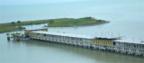
Malacca island or Pulau Melaka is a man-made island in Malacca town. it's linking to the mainland by a 30 m bridge on a side and has a jetty on the other side.
Pulau Panjang, a narrow, rocky flat almost covered at HW, lies 2 miles SSE of St. Paul’s Hill, and is steep-to on its S side. A stone beacon stands on its E end and a lighted beacon on its W end.
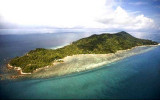
Pulau Jawa, consisting of two wooded islets nearly joined together, lies 0.75 mile S of St. Paul’s Hill; the W islet is 18.3m high to the tops of the trees, and the E islet 6.1m high to the tops of the trees.
Batu Gelama, a rock which covers at HW, is marked by a lighted beacon. A narrow ridge with depths of less than 5.5m extends about 1 mile WNW and 0.3 mile ESE of the beacon. Two 4.9m patches lie between the NW end of this ridge and the ridge extending SE from Pulau Upeh.
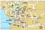
The town of Melaka (Malacca), capital city of the Malaysian state of Melaka, stands on both banks of the Melaka River which discharges about 6 miles E of Tanjong Keling, the two parts being connected by several bridges.
St Paul's Hill, wich is conspicuous, stands on the left bank ...


 Foulerton Shoal, with a depth of 10.4m, lies about 0.7 mile SSE of the lighted beacon on Pulau Panjang. A small sandy shoal, with a depth of 4.6m, lies about 0.2 mile NNW of the beacon on the E end.